The geographical features of India consist of the peninsula which is surrounded by water on three sides, the world’s highest mountain ranges in the north, the desert in Rajasthan, etc.
Coast and Land Boundary of India
India shares a 15,200 Km land frontier in the west with Pakistan, northwest with Afghanistan, Nepal-China-Bhutan in the north, and Bangladesh-Myanmar in the east and also shares the longest border with Bangladesh with 4156 km and shares the shortest border with Afghanistan at 106 km.
The country has a coastline of 6100 km with three sides, namely the Indian Ocean, and its two arms lie on the Arabian Sea in the west, and in the east, it is the Bay of Bengal. The total length of India’s coastline including the islands is 7516.6 km.
The Palk Strait, a narrow and shallow sea, separates India and Sri Lanka.
India’s Geographic Location in the World
India’s landmass is centrally located between East and West Asia. India has a southward extension to the Asian continent and the Indian Ocean. India has a strategic location as it is located in the trans-Indian Ocean route that connects Europe and East Asia.
This helps in establishing contact with West Asia, Africa, and Europe
India: A Subcontinent
India, along with Myanmar, Bangladesh, Pakistan, Nepal, Bhutan, and Sri Lanka, forms the Indian Subcontinent. A chain of mountains in the northwest, north, and northeast separates this area from Asia. Also separated by Sea in the South.
This region’s unique continental characteristics in physiography, climate, natural vegetation, minerals, etc., define it as a subcontinent. Therefore, people call India a subcontinent.
The physical features of India
- Geographically India’s physical features are divided into five physiographic divisions:
- Himalayas
- Great Northern Plains
- Peninsular Plateau
- Great India Desert
- Coastal Plains
- Islands
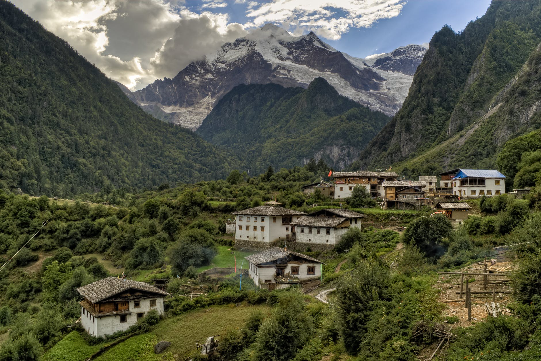
1. The Himalayan mountains
The Himalayan mountains (northern mountains) are the youngest and the loftiest mountain chains in the world. Tectonic activity folded the earth’s crust, forming the Himalayas only a few million years ago.
Himalaya stretches for a distance of about 2,500 Km from the Indus Gorge in the west to the Brahmaputra Gorge in the east. The width of the Himalayas varies from 500 km in Kashmir to 200 Km in Arunachal Pradesh.
People famously refer to the Pamir Knot as the “Roof of the World,” which connects the Himalayas and the high ranges of Central Asia. From the Pamir Knot, the Himalayas extend eastwards in an arc.
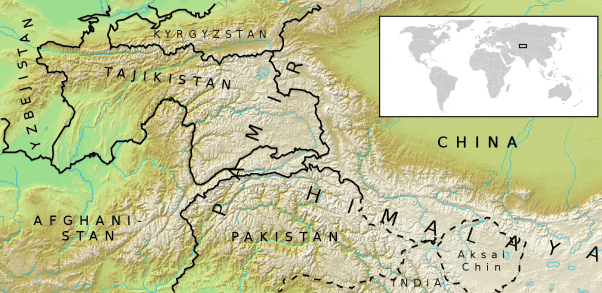
Pamir Knot in India Map
The term Himalaya means “Abode of Snow” in the Sanskrit language. The Himalayas act as a great wall and are classified into three divisions:
- Trans Himalayas
- Himalayas
- Eastern or Purvanchal Hills
The Aravalli range is the oldest fold mountain range in India.
1.1 The Trans-Himalayas
The western Himalayas also known as the Trans-Himalayas lie to the north of the great Himalayan Range. It lies in the Tibetian plateau and Jammu-Kashmir. The western Himalayas are about 40km wide in the eastern and western extremities.
It is about 225 km wide in its central part. The trans-Himalayas contain the Tethys sediments. This region’s rock contains fossil-bearing marine sediments which underlie ‘Tertiary granite. It also has partly metamorphosed sediments and constitutes the core of the Himalayas axis.
The prominent ranges of Trans-Himalayas are Zaskar, Ladakh, Kailash, and the Karakoram.
1.2 The Himalayas
The Himalayas constitute the core part of the northern mountains and are young-fold mountains. The movement of the Angara landmass in the north and the Gondwana landmass in the south formed it.
The compression uplifted the Tethys sea found between these two landmasses, resulting in the formation of the Himalayas. The Himalayas consist of many ranges.
- Greater Himalayas
- Lesser Himalayas
- Siwaliks
| Peak | Country | Height in metres |
| Mt. Everest | Nepal | 8848 |
| Mt.K2 or Godwin Austen | India | 8611 |
| Kanchenjunga | India | 8598 |
| Makalu | Nepal | 8481 |
| Dhaulagiri | Nepal | 8172 |
| Nanga Parbat | India | 8126 |
| Annapurna | Nepal | 8078 |
| Nanda Devi | India | 7817 |
| Kamet | India | 7756 |
| Namcha Barwa | India | 7756 |
| Gurla Mandhata | Nepal | 7728 |
Himalayan Mountain Ranges with its Height and country
The Himalaya is the home of several high peaks. However, it holds the record of having the maximum number of highest peaks among any mountain range in the world. Out of the 14 highest peaks in this world, the Himalayas hold 9.
1.2.1 The Greater Himalayas or the Himadri
The Himadri rises abruptly like a wall north of the lesser Himalayas. It is 25 km wide and the average height is about 6000m. The Greater Himalayas receive lesser rainfall compared to the lesser Himalayas and the Siwaliks. Physical weathering is less effective over the Greater Himalayas (Himadri) compared to the other ranges.
Almost all the lofty peaks of the Himalayas are located in this range. The famous ones are Mt.Everest (8,848m) and Kanchenjunga (8,586m). Mt.Everest is located in Nepal and Kanchenjunga is located between Nepal and Sikkim.
This range is the most continuous of all ranges. It is a region of permanent snow cover. It has many glaciers, Gangotri, Yamunotri, and Siachen are famous ones.
1.2.2 The Lesser Himalayas or The Himachal
The Himachal (Lesser Himalayas) is in the middle range of the Himalayas. The height of this range varies from 3,700 to 4,500m. Its width varies up to 80 km. The major rocks of the Himachal ranges are slate, limestone, and quartzite.
Heavy rainfall, deforestation, and urbanization expose this region to extensive erosion. The Pir Panjal, Dhauladhar, and Mahabharat are the mountain ranges found here. Major hill stations of the Himalayas are located in the Lesser Himalayas (Himachal). Shimla, Mussourie, Nainital, Almora, Ranikhet, and Darjeeling are the famous ones.
Major Passes in the Himalayan
- Karakoram Pass in Jammu Kashmir.
- Zojila Pass, Shipkila Pass in Himachal Pradesh
- Bomdila Pass in Arunachal Pradesh
- Nathala Pass and Jhelepla Pass in Sikkim
- Khyber Pass which connects Pakistan and Afghanistan
- Bolan Pass in Pakistan is an important pass of the Indian Subcontinent.
1.2.3 The Siwaliks or Outer Himalayas
The Siwaliks extend from Jammu and Kashmir to Assam. It is partly made by the debris brought by the Himalayas rivers. The altitude varying between 900-1100 meters elevation of this range is 1300m. The width of Siwaliks varies from 10km in the east to 50km in the west.
It is the most discontinuous range.
Duars and Duns
The longitudinal valleys found between the Siwaliks and the Lesser Himalayas are Duns in the west. In the east it is Duars. These are the ideal sites for settlements in this region.
———————–
1.3 Purvanchal Hills
Purvanchal Hills are the eastern offshoot of the Himalayas. These ranges extend to the northeastern states of India. The states lying in the Purvanchal hill ranges are Arunachal Pradesh, Nagaland, Manipur, Mizoram, Tripura, and eastern Assam.
Most of the Purvanchal hills are located along the border of India and Myanmar and some are inside India.
Purvanchal Hills or Purvanchal Ranges are collection of hill such as Dafla Hills, Abor Hills, Mishmi Hills, Patkai Bum Hills, Naga Hills, Manipur Hills, Mizo Hills, Tripura Hills, Mikir Hills, Garo Hills, Khasi Hills, and Jaintia Hills.
Longitudinal Divisions of Himalayas
Longitudinal division of Himalayas
- The Kashmir Punjab Himachal Himalayas are located between the rivers of Indus and Sutlej.
- The Kumaun Himalayas are located between the rivers of Sutlej and Kali.
- The Central-Nepal Himalayas are located between the rivers of Kali and Tista.
- The Assam Eastern Himalayas are located between the rivers of Tista and Dihang.
The Great Northern Plains
The fertile land extending across seven north Indian states forms the great northern plains. These extensive plains lie to the south of the northern mountains. This plain is one of the most extensive stretches of alluvium in the world and is deposited by the river Indus, Ganga, Brahmaputra, and its tributaries.
The length of the plain is about 2400 km and the width varies from 240 to 320 km. Its width increases from east to west. It covers an area of over 7 lakh sq. km. The great plains of India are formed mostly by the depositional process of the Himalayan and Vindhyan rivers.
These rivers deposit sediments along the foothills and flood plains. The important characteristics and features of sediment deposition in the plains areas are as follows.
1. The Bhabar Plain
This plain is made of unassorted sediments and gravel deposited by the rivers of the Himalayas. Small stream flow disappears in this region due to the high porosity of this plain. Bhabar Plain lies to the south of the Siwalik from west to east (Jammu Division to Assam).
The width of the Bhabar Plain varies from 8 to 15km. It is wider in the western plains (Jammu Division) than in the east (Assam). This plan is not suitable for cultivation, and only big trees with large roots thrive in this region.
2. The Tarai Tract or Teraje Region of India
The Tarai Tract is a zone of excessive dampness with thick forests and rich wildlife and is located in the south of Nepal and northern India which is parallel to the lower Himalayas. It is stretched from the Brahmaputra in the east and Yamuna in the west.
It lies south of the Bhabar plains. The width of the Tarai Tract is 15 to 30 Km and is wider in the eastern of the Great Plains especially in the Brahmaputra Valley because of the heavy rainfall.
The Tarai forest is cleared for farming in many states. The Tarai region is important as it provides connectivity to Eastern Himalayas across Nepal. The ecological importance of the Tarai region has Tiger, Elephant, Asian Rhino, etc.
In Nepal, the Tarai region is referred to as the “Granary of Nepal”, as the soil in this region is very fertile and receives good rainfall and a suitable climate for agriculture.
3. The Bhangar Plains
The Bhangar represents the upland alluvial tracts of the Great Plains of India. It is formed by the older alluvium. The Bhangar land lies above the flood limits of the rivers. This soil is dark in colour, rich in humus content, well-drained, and useful for agriculture.
4. The Khadar Plains
The new alluvium tracts along the courses of the rivers are known as Khadar or Bet lands. The Khadar tracts are enriched by fresh deposits of silt every year during rainy seasons. The Khadar land consists of sand, silt, clay, and mud. It is highly fertile soil.
5. Delta Plains
The deltaic plain is an extension of the Khadar land. It covers 1.9 Lakh sq. km in the lower reaches of the Ganga River. It is an area of deposition as the river flows in this tract sluggishly.
Chars and Bils
The deltaic plains consist of old mud, new mud, and marsh. In the delta region, the uplands are called ‘Chars‘. And the marshy areas are called ‘Bils’.
The Peninsular Plateaus
It lies to the south of the Great Northern Plains. This is the largest Physiographic division in India. Peninsular Plateaus cover about 16 lakh sq. km (about half of the total area). It is an old rocky plateau region. The topography has a series of plateaus and hill ranges interspersed with rivers.
Aravalli hills mark the north-western boundary of the plateau region. Its northern and northeastern boundaries are marked by the Bundelkhand upland, Kaimur, and Rajmahal hills. The Western Ghats and the Eastern Ghats mark the western and eastern boundaries respectively.
The altitude of a large portion of the plateau is more than 600m from the mean sea level. The peak of Anaimudi is the highest point in the plateau, its height is 2695m, and is located in Anaimalai. The general slope of this plateau is towards the east.
The Great Plateau is a part of the Gondwana landmass. Due to old age, rivers in this region attained their base level and developed broad and shallow valleys. The river Narmada divides the plateau region of India broadly into two parts.
The region lying to the north of Narmada is called the Central Highlands, and the region lying to the south of Narmad is called the Deccan Plateau. All the major rivers such as Mahanadi, Godavari, Krishna, Kaveri, etc. lie to the south of the Vindhyas that flow eastwards and fall into the Bay of Bengal. Narmada and Tapti are the two rivers situated to the south of the Vindhyas flow westward.
Their movement towards the west is due to the presence of a rift valley in the region.
1. Central Highlands
The Central Highlands lies between the Narmada River and the Northern Great Plains. The Aravallis form the west and northwestern edge of the Central Highlands. These hills extend from Gujarat, through Rajasthan to Delhi in the Northwesterly direction for a distance of about 700km.
The height of these hills is about 1500m in the southwest while near Delhi the height is hardly 400m. Guru Shikhar with 1722m is the highest peak of this range. The western part of the central highland is known as the Malwa Plateau. It lies to the southeast of Aravallis and to the north of the Vindhyachal range.
The rivers Chambal, Betwa, and Ken drain the Malwa plateau before they join the river, Yamuna.
- The part of the Central Highlands that extends to the east of Malwa Plateau is known as Bundelkhand and its further extension is known as Bagelkhand.
- The eastern part of the central Highlands which lies in the north-eastern part of the Indian plateau is known as Chhota-Nagpur Plateau.
- It covers much of Jharkhand, and adjacent parts of Odisha, West Bengal, Bihar, and Chhattisgarh.
- This region is very rich in mineral resources, particularly iron ore and coal.
2. Deccan Plateau
It is the largest part of the plateau region of India. The shape of this plateau is almost triangular. On the sides of the triangle is marked by a line joining Kanyakumari with Rajmahal Hills and this line passes through the Eastern Ghats.
The second arm is marked by Satpura Range, Mahadeo Hills, Maikal Range, and the Rajmahal Hills. The third arm is marked by the Western Ghats. The total area is about 7 lakh square km and the height ranges from 500 to 1000m above sea level.
The Western Ghats form the western edge of the Peninsular Plateau and run parallel to the Arabian Sea Coast. The northern part of this range is called Sahyadris. The height of the Sahyadris increases from north to south. Anaimudi is a sort of tri-junction of the Anaimalai range, the cardamom hills, and the Palani hills.
Kodaikanal is a hill resort situated on the Palani Hills. The Eastern Ghats run from southwest to northeast from the eastern edge of this plateau. This range is also called Poorvadri. The Eastern ghats join the western ghats at the Nilgiri hills, bordering Karnataka and Tamil Nadu.
The Eastern ghats are not continuous like the Western ghats. The rivers of Mahanadi, Godavari, Krishna, Pennar, and Kaveri have dissected this range in many places.
The Indian Desert
The Thar desert, also known as the Great Indian Desert is a large arid region in the northwestern part of the Indian subcontinent that covers an area of 2,00,000 sq. km and forms a natural boundary between India and Pakistan. It is the world’s 7th largest desert and the world’s 9th largest subtropical desert located in the western part of India.
The desert lies in the western part of the Aravali range and covers 2/3 of Rajasthan state. There are two major divisions in the Thar desert and they are the Actual desert region called Marusthali and the semi-desert region called Bhangar. And different types of sand dunes and salt lakes called Dhands are seen here.
The Coastal Plains
The Peninsular Plateau of India is flanked by narrow coastal plains of varied width from north to south known as the Western Coastal Plains and the Eastern Coastal Plains. They were formed by the depositional action of the river and the erosional and depositional actions of the sea waves.
The Indian coastal plains are divided into Western and Eastern Coastal Plains.
1. The Western Coastal Plain
The western coastal plain lies between the Western Ghats and the Arabian Sea. It extends from Rann of Kutch in the North to Kanyakumari in the south and its width varies from 10 to 80 km. It is mainly characterized by Sandy beaches, coastal sand dunes, mudflats, lagoons, estuary, laterite platforms, and residual hills.
The northern part of the west coastal plain is known as the Konkan plain. The middle part of this plain is known as Kanara. The southern part of the plain is known as the Malabar coast which is about 550km long and 20-100 km wide.
This part of the coast is characterized by sand dunes. Along the coast, there are numerous shallow lagoons and backwaters called Kayals and Teris. Vembanad is a famous backwater lake found in this region.
2. The Eastern Coastal Plain
It lies between the eastern ghats and the Bay of Bengal and it stretches along with the states of West Bengal, Odisha, Andhra Pradesh, and Tamil Nadu. These plains are formed by the alluvial fillings of the littoral zone by the east-flowing rivers of India. The coastal plain consists mainly of the recent alluvial deposits.
This coastal plain has a regular shoreline with well-defined beaches.
- The coastal plain between the Mahanadi and Krishna Rivers is known as the Northern Circars and the southern part lies between the Krishna and Kaveri Rivers is called the Coromandel Coast.
- The Marina Beach on this coast in Chennai is the second-longest beach in the world.
Important Lakes in the Eastern Coastal Plain
Among the backwater lakes of this coast, lake Chilka (Odisha) is the largest lake in India located to the southwest of the Mahanadi delta, the Kolleru Lake lies between the deltas of Godavari and Krishna, and the Pulicat Lake lies on the border of Andhra Pradesh and Tamil Nadu are the well-known lakes in the eastern coastal plain.
The Islands of India
There are two major island groups namely Andaman-Nicobar and Lakshadweep. Andaman and Nicobar Islands consist of 572 islands and are located in the Bay of Bengal. Lakshadweep Islands are located in the Arabian Sea and have 27 islands that are mainly of coral origin.
The Andaman and Nicobar Islands are of largely tectonic and volcanic origin. India’s only active volcano is found on Barren Island in Andaman and Nicobar Islands.
1.Andaman and Nicobar Islands
Andaman and Nicobar Islands are located in an elevated portion of the submarine mountains. It lies close to the equator, as a result, it remains hot and wet throughout the year and has a dense forest. The area of the island group is about 8249 sq km.
The entire group of islands is divided into two, which are Andaman in the North and Nicobar in the South. Andaman and Nicobar Islands are of great strategic importance for the country. Port Blair is the capital of Andaman and Nicobar Islands.
The Ten Degree Channel separates Andaman from the Nicobar group. The southernmost tip, Indira Point is a part of Nicobar Island
The southernmost tip of India, which is Indira Point is located at the latitude of 6°45’N or 6-1/2 N which is part of Nicobar Island.
2. Lakshadweep Islands
Lakshadweep archipelago is a group of coral islands situated off the west coast of the Indian Subcontinent. The administrative capital of Lakshadweep is Kavaratti. The Eight Degree Channel separates the Lakshadweep from the Maldives Islands.
Their uninhabited Island is known as Pitt Island, which has a bird sanctuary. Lakshadweep has three divisions earlier namely Laccadive, Minicoy, and Amindivi. It was named Lakshadweep in 1973.
3. Offshore Islands
Besides Andaman-Nicobar and Lakshadweep islands, India has a number of Islands along the Western Coast, Eastern Coast, in the delta region of Ganga, and in the Gulf of Mannar. Many of these islands are uninhabited and are administered by the adjacent states.
India Location
The latitude and longitude extent of India
India extends from 8°4 ‘N to 37°6 ‘N latitude and 68°7 ‘E to 97°25 ‘E longitudes. India is located in the North-Eastern Hemisphere. The Southernmost part of India is Indira Point or 6-1/2 N latitude is 6°45’N latitude and is located in the Andaman and Nicobar Islands.
The southernmost point of the mainland is Cape Comorin or Kanyakumari. The north-south extent of India is 3214 km, it extends from Indira Col in Jammu and Kashmir to Kanyakumari in Tamil Nadu. The east-west extension is 2933 km, it extends from Rann of Kutch in Gujarat in the west to Arunachal Pradesh in the east.
The tropic of Cancer at 23°30′ N passes through the center of the country and divides the country into two halves. One half is northern temperate and the other half is southern tropical lands. India is politically divided into 28 states and 8 union territories as of 16-11-2020.
The newly formed union territories are Jammu and Kashmir, and Ladakh after the removal of Article 370. Total union territories along the west coast are Diu Daman-Dadra Nagar Haveli, Mahe (Pondicherry), and Lakshadweep. Totally three.
The number of union territories on the eastern coast is Puducherry and Andaman Nicobar Islands. Totally two. The smallest state in India is Goa. The largest state in India is Rajasthan.
The smallest union territory in India is Lakshadweep. The largest union territory is the Andaman & Nicobar Islands. The largest district in India is Kachchh (Gujarat). The smallest district in India is Mahe (Pondicherry).
The states that do not have an international border or lie in the largest state Rajasthan are Haryana, Uttar Pradesh, and Madya Pradesh. The states that do not have an international border or lie on international coastal boundaries are Haryana, Jharkhand, Madhya Pradesh, Chhattisgarh, and Telangana.
Conclusion
This post is for the topic ‘Location – Physical Features of India‘ for the Tnpsc exam. These notes are taken from Samacheer Kalvi’s book 10th Standard. It is also useful for Upsc and other state service exams.
References
Download
1.Physical features of India Upsc pdf
2.Geographical features of india upsc pdf
3.Location and physical features of india Tnpsc pdf (10th Samacheer)