Definition and Characteristics of Natural Vegetation
- Natural vegetation refers to a plant community left undisturbed over a long time, allowing individual species to adjust fully to climate and soil conditions.
- It differs from planted vegetation, which grows under human supervision in places like gardens or orchards.
- India possesses a vast variety of natural vegetation that changes from one region to another based on soil and climatic variations.
- Examples of this variety include temperate vegetation in the Himalayas, tropical rain forests in the Western Ghats and Andaman Nicobar Islands, tropical forests and mangroves in delta regions, and cactii, bushes, and thorny vegetation in the desert and semi-desert areas of Rajasthan.
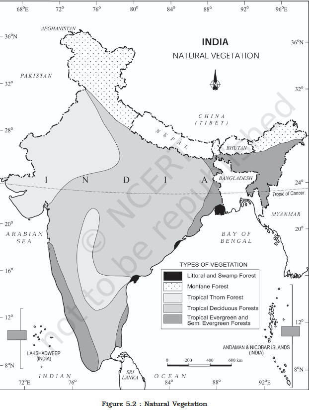
Classification of Indian Forests
- Indian forests are divided into five main groups based on predominant vegetation types and climatic regions: (i) Tropical Evergreen and Semi Evergreen forests, (ii) Tropical Deciduous forests, (iii) Tropical Thorn forests, (iv) Montane forests, and (v) Littoral and Swamp forests.
- The British altered the structure of Indian forests for commercial use by exploiting them on a large scale, such as replacing oak forests in Garhwal and Kumaon with pine (chirs) to build railway lines, clearing forests for tea, rubber, and coffee plantations, and using timber for construction due to its heat insulating properties.
Tropical Evergreen and Semi Evergreen Forests
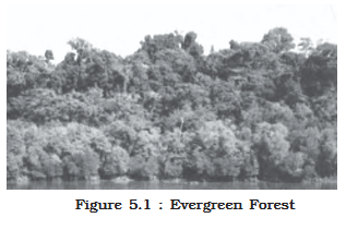
- These forests are located on the western slope of the Western Ghats, the hills of the northeastern region, and the Andaman and Nicobar Islands.
- They thrive in warm, humid areas with an annual precipitation over 200 cm and a mean annual temperature above 22°C.
- Tropical evergreen forests are well stratified, featuring ground layers covered in shrubs and creepers, short structured trees, and tall trees that reach heights of 60 m or above.
- They appear green all year round because the trees have no definite time to shed their leaves, flower, or fruit.
- Key species include rosewood, mahogony, aini, and ebony.
- Semi evergreen forests are found in the less rainy parts of these regions and contain a mixture of evergreen and moist deciduous trees.
- Undergrowing climbers give semi evergreen forests an evergreen character, featuring main species like white cedar, hollock, and kail.
Tropical Deciduous Forests
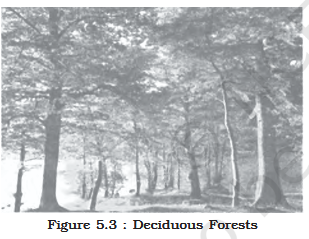
- Also known as monsoon forests, these are the most widespread forests in India, covering regions that receive between 70-200 cm of rainfall.
- They are divided into moist and dry deciduous forests depending on water availability.
- Moist deciduous forests: Found in regions receiving 100-200 cm of rainfall, specifically in northeastern states along the Himalayan foothills, the eastern slopes of the Western Ghats, and Odisha. Main species include teak, sal, shisham, hurra, mahua, amla, semul, kusum, and sandalwood.
- Dry deciduous forests: Cover vast areas receiving 70-100 cm of rainfall, transitioning to moist deciduous forests on wetter margins and thorn forests on drier margins.
- They are found in the rainier areas of the Peninsula and the plains of Uttar Pradesh and Bihar, presenting a parkland landscape with open stretches of teak and patches of grass.
- During the dry season, the trees shed their leaves completely, creating a landscape that resembles a vast grassland with naked trees.
- Common dry deciduous trees include tendu, palas, amaltas, bel, khair, and axlewood.
- Due to low rainfall and overgrazing, vegetation cover is very scanty in the western and southern parts of Rajasthan.
Tropical Thorn Forests
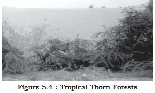
- Found in areas receiving less than 50 cm of rainfall, consisting of various grasses and shrubs.
- These forests cover the semi-arid areas of south west Punjab, Haryana, Rajasthan, Gujarat, Madhya Pradesh, and Uttar Pradesh.
- Plants remain leafless for most of the year, giving the appearance of scrub vegetation.
- Important plant species are babool, ber, wild date palm, khair, neem, khejri, and palas, with tussocky grass growing up to 2 m high as undergrowth.
Montane Forests
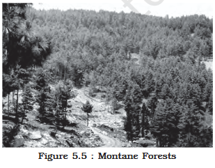
- Mountain forests change in natural vegetation based on decreasing temperatures with increasing altitude and are classified into northern and southern mountain forests.
- Northern Mountain (Himalayan) Forests: Feature a succession of vegetation from tropical to tundra based on altitude.
- Deciduous forests exist in the Himalayan foothills, followed by wet temperate forests at altitudes of 1,000-2,000 m.
- Evergreen broad leaf trees like oak and chestnut predominate in higher hill ranges of northeastern India, hilly areas of West Bengal, and Uttaranchal.
- Pine forests develop between 1,500-1,750 m, featuring Chir Pine as a commercial tree, while Deodar, an endemic species valued for construction, grows in the western Himalayas.
- Chinar and walnut trees, which sustain Kashmir handicrafts, belong to this zone.
- Blue pine and spruce appear at 2,225-3,048 m, along with temperate grasslands.
- Alpine forests and pastures occur between 3,000-4,000 m, featuring silver firs, junipers, pines, birch, and rhododendrons.
- Alpine pastures are extensively used for transhumance by tribes such as the Gujjars, Bakarwals, Bhotiyas, and Gaddis.
- Mosses and lichens form tundra vegetation at the highest altitudes.
- The southern slopes of the Himalayas carry a thicker vegetation cover than the drier north-facing slopes due to relatively higher precipitation.
- Southern Mountain Forests: Found in three areas of Peninsular India: the Western Ghats, the Vindhyas, and the Nilgiris.
- Being closer to the tropics and only 1,500 m above sea level, they have subtropical vegetation in lower regions and temperate vegetation in higher regions of the Western Ghats (Kerala, Tamil Nadu, and Karnataka).
- The temperate forests are known as Sholas in the Nilgiris, Anaimalai, and Palani hills.
- Significant trees include magnolia, laurel, cinchona, and wattle, and such forests are also present in the Satpura and Maikal ranges.
Littoral and Swamp Forests
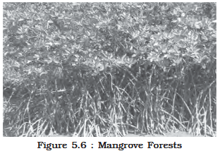
- India possesses 3.9 million hectares of wetland habitats, with about 70 percent under paddy cultivation.
- Chilika Lake (Odisha) and Keoladeo National Park (Bharatpur) are protected water-fowl habitats under the Ramsar Convention, an international agreement among UN member states.
- Wetlands are grouped into eight categories: (i) Deccan Plateau reservoirs and southern west coast lagoons; (ii) saline expanses in Rajasthan, Gujarat, and the Gulf of Kachchh; (iii) freshwater lakes/reservoirs from Gujarat through Rajasthan to Madhya Pradesh; (iv) delta wetlands and lagoons of the east coast; (v) freshwater marshes of the Gangetic Plain; (vi) Brahmaputra floodplains and northeast/Himalayan marshes; (vii) lakes and rivers in the montane regions of Kashmir and Ladakh; (viii) mangrove forests and wetlands of the Andaman and Nicobar Islands.
- Mangroves are salt-tolerant plant species growing along coasts in salt marshes, tidal creeks, mud flats, and estuaries.
- India has 4,992 sq. km of mangrove forests, representing 7 percent of the world’s mangrove forests.
- They are highly developed in the Andaman and Nicobar Islands, the Sunderbans of West Bengal, and the Mahanadi, Godavari, and Krishna deltas, providing shelter to birds but requiring conservation due to encroachment.
Forest Conservation and Policy
- The Government of India adopted a forest conservation policy in 1952, modified in 1988, to emphasize sustainable forest management, conserve/expand forest reserves, and meet local needs.
- The policy aims to: bring 33 percent of geographical areas under forest cover; maintain environmental stability and ecological balance; conserve natural heritage, biodiversity, and genetic pools; check soil erosion, desert extension, floods, and droughts; increase forest cover via social forestry and afforestation; increase productivity of timber, fuel, fodder, and food for rural populations; and create a massive people’s movement involving women to plant trees and stop felling.
- Forests are intrinsically linked to the lives of tribal communities, providing them with food, shelter materials, arts, and livelihood.
- The policy encourages treating tribals as growers of minor forest produce and incorporating their age-old forestry knowledge into conservation rather than viewing them merely as collectors.
Social and Farm Forestry
- Social Forestry: Defined as the management, protection, and afforestation of barren lands to aid in environmental, social, and rural development.
- The National Commission on Agriculture (1976) classified social forestry into three types: Urban, Rural, and Farm forestry.
- Urban Forestry: Raising and managing trees on public and private lands in/around urban centers (e.g., green belts, parks, roadside avenues).
- Rural Forestry: Focuses on agro-forestry and community-forestry.
- Agro-forestry: Raising trees alongside agricultural crops on the same land to simultaneously produce food, fodder, fuel, timber, and fruit.
- Community Forestry: Raising trees on public land (village pastures, temple land, roadsides, canal banks, railways, schools) to benefit the whole community, providing a means for landless classes to participate and benefit.
- Farm Forestry: Farmers growing trees for commercial and non-commercial purposes on their farm lands (like margins of fields, grasslands, or around homes), often supported by free seedling distributions from state forest departments.
Wildlife and Conservation in India
- India contains about 4-5 percent of all known plant and animal species on earth due to its great ecosystem diversity.
- Wildlife populations have dwindled, placing some species at the brink of extinction, due to reasons like: industrial/technological exploitation, land clearing for agriculture/settlements/mining, lopping for fodder and fuelwood, domestic cattle grazing, elite hunting and commercial poaching, and forest fires.
- The Wildlife Act of 1972 provides the legal framework for wildlife protection, aiming to protect endangered species and provide legal support to National parks, sanctuaries, and closed areas.
- The Act was amended in 1991 to make punishments more stringent and protect specified plant and endangered animal species.
- India has 107 National parks and 573 wildlife sanctuaries.
- Project Tiger (1973): Launched to maintain a viable tiger population for scientific, aesthetic, cultural, and ecological values; expanded from 9 reserves (16,339 sq. km) to 58 reserves (84,487 sq. km) across 18 states, increasing the tiger population from 1,411 in 2006 to 3,682 in 2023 (over 75 percent of the global population).
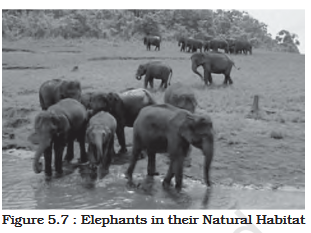
- Project Elephant (1992): Launched to ensure long-term survival of viable free-ranging wild elephant populations in 18 states.
- Other launched projects include the Crocodile Breeding Project, Project Hangul, and conservation of the Himalayan Musk deer.
- Biosphere Reserves: Unique terrestrial and coastal ecosystems recognized under UNESCO’s Man and Biosphere (MAB) Programme to achieve conservation of biodiversity, development associated with the environment, and an international network for research (logistics).
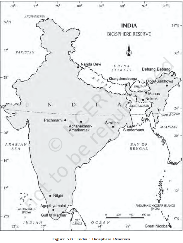
- There are 18 Biosphere Reserves in India, 12 of which are recognized by UNESCO on the World Network of Biosphere Reserves.
- These reserves include Nilgiri, Nanda Devi, Nokrek, Manas, Sunderban, Gulf of Mannar, Great Nicobar, Similipal, Dibru-Saikhowa, Dehang Debang, Pachmarhi, Khangchendzonga, Agasthyamalai, Achanakmar-Amarkantak, Kachchh, Cold Desert, Seshachalam, and Panna.
| Sl. No. | Name of the Biosphere Reserve | Year of Designation | States/UT |
| 1. | Nilgiri | 1986 | Tamil Nadu, Kerala and Karnataka. |
| 2. | Nanda Devi | 1988 | Uttarakhand. |
| 3. | Nokrek | 1988 | Meghalaya. |
| 4. | Manas | 1989 | Assam |
| 5. | Sunderban | 1989 | West Bengal. |
| 6. | Gulf of Mannar | 1989 | Tamil Nadu. |
| 7. | Great Nicobar | 1989 | Andaman and Nicobar Islands. |
| 8. | Similipal | 1994 | Odisha. |
| 9. | Dibru-Saikhowa | 1997 | Assam |
| 10. | Dehang Debang | 1998 | Arunachal Pradesh. |
| 11. | Pachmarhi | 1999 | Madhya Pradesh. |
| 12. | Khangchendzonga | 2000 | Sikkim |
| 13. | Agasthyamalai | 2001 | Tamil Nadu, Kerala. |
| 14. | Achanakmar-Amarkantak | 2005 | Madhya Pradesh, Chhattisgarh |
| 15. | Kachchh | 2008 | Gujarat. |
| 16. | Cold Desert | 2009 | Himachal Pradesh. |
| 17. | Seshachalam | 2010 | Andhra Pradesh. |
| 18. | Panna | 2011 | Madhya Pradesh. |
Note: Sites with bold letters in the original document indicate inclusion in the World Network of BRs of UNESCO. Source: Annual Report 2024-25, Ministry of Environment and Forests, Government of India.
