Definition
It is an imaginary line dividing the surface of the Earth, which runs from the North Pole to the South Pole and demarcates the border between one calendar day and the next. It serves as the “line of demarcation” between the two calendar days.
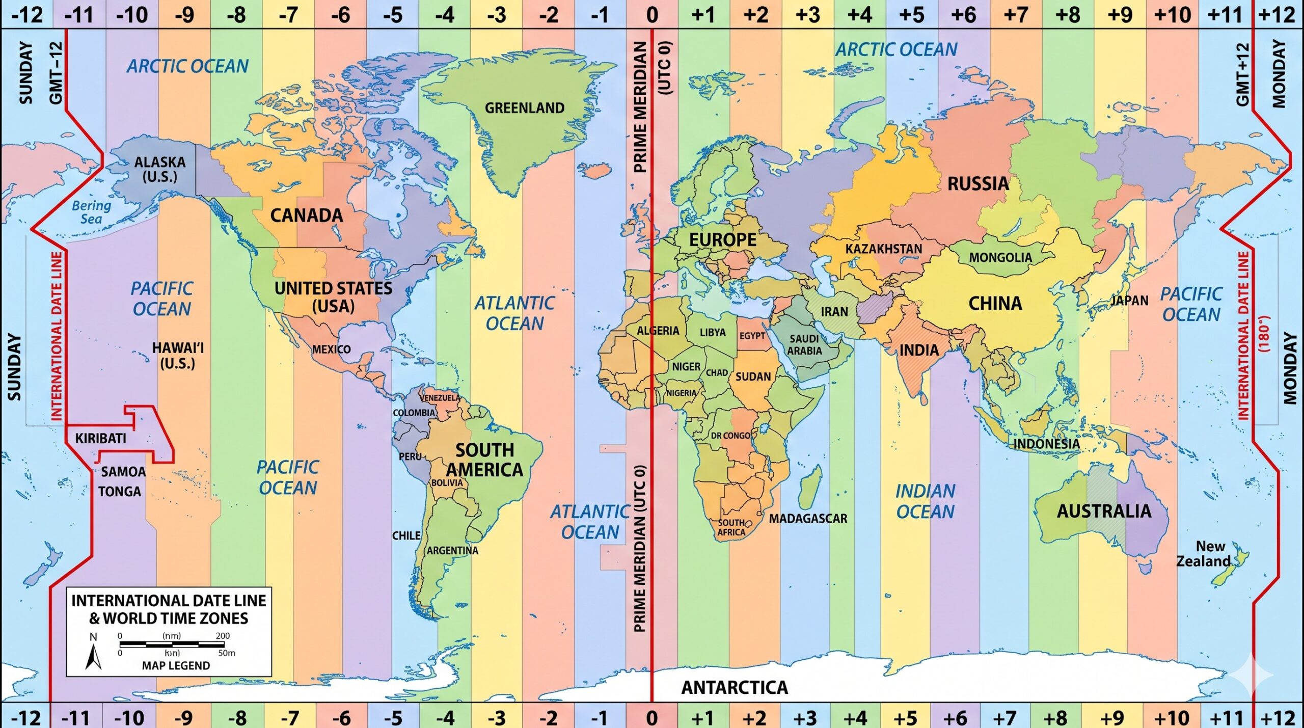
International Date Line on world map
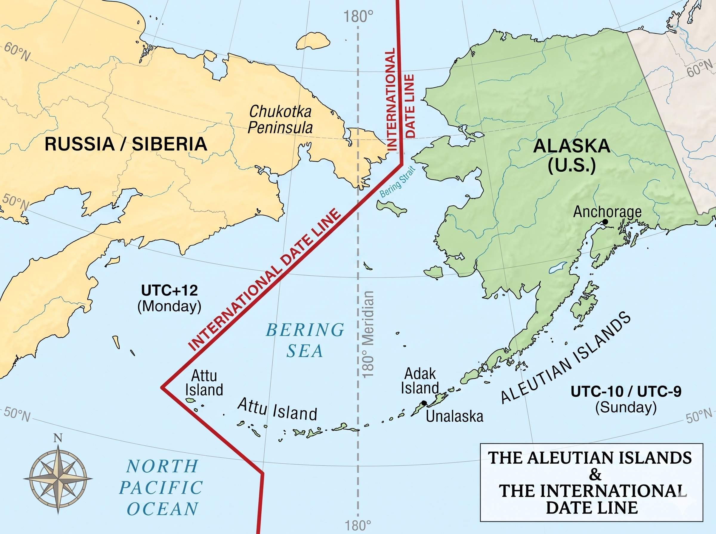
As seen on the world map below, the International Date Line runs north and south across the middle of the Pacific Ocean. The date line does not follow the meridian exactly. It bends once to the west and once to the east. The actual date line passes through the middle of the Bering Strait, then it turns to the southwest until it reaches the middle of 170° east longitude. As shown in the image below.
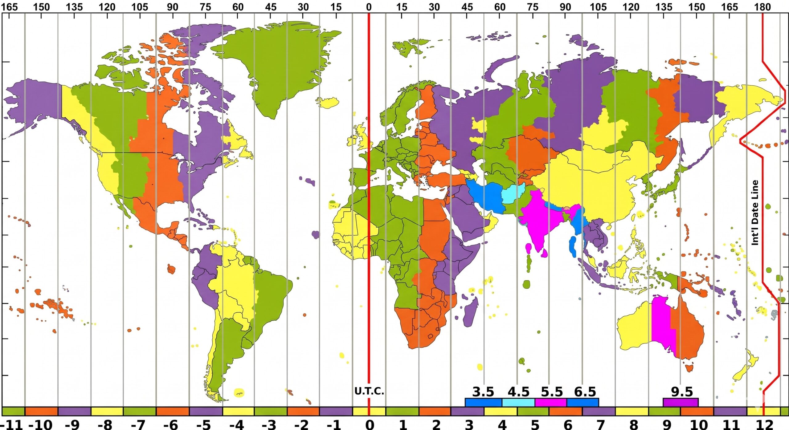
As shown in the International Date Line on the world map above, we see that the Aleutian Islands are all on the American side of the line, and it sweeps eastward again to the 180th meridian, which it follows to the Fiji Islands.
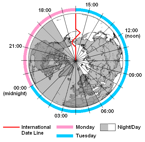
As shown in the International Date Line on world map above, we see that the Aleutian Islands are all on the American side of the line, and it sweeps eastward again to the 180th meridian, which it follows to the Fiji Islands. As these Islands, and many other small islands in these regions below to Great Britain and are politically connected with Australia and New Zealand politically connected with Great Britain, the line swings again to the east, giving the British possession the same calendar day.
After this deflection, the International Date Line returns to the 180th meridian, which passes through the frozen regions of the Antarctic Ocean.
International Date Line for Ships
A ship sailing eastward, when crossing the date line, always drops a day out of its calendar. It is because the ship passes from the region of the new day into that of the day before.
For this reason, a ship sailing westward while crossing the date line adds another day. Since the ship leaves the region of the day it was in and enters the region of the new day.
Example 1: The ship crosses the date line eastward on Monday, dropping the day out of its calendar and going back to Sunday again.
Example 2: When the ship crosses westward on Monday, the ship immediately takes up the next day ahead or Tuesday.
This is how the International Date Line on world map is important for sailing and helps in determining the date during a sea voyage.
International Date Line and its coordinates
- Latitude: 0° 00′ 0.00″ N
- Longitude: -180° 00′ 0.00″ W
How does the international date line work?
The curious thing that brought out this date line is the fact that the total duration or life of each day. When you consider the entire globle and not just a single locality, a day is 48 hours instead of 24 hours.
For example, imagine a person close to
Prime meridian
Is the Prime Meridian and the International Date Line the same thing?
The Prime Meridian separates the Eastern Hemisphere from the Western Hemisphere. International Date Line is halfway around the world, at 180-degree Longitude. The Prime Meridian is present at 0 degrees Longitude.
What is the time difference between the IDL and the Prime Meridian?
The time difference between the International Date Line and the Prime Meridian is 12 Hours.
IDL Latitude and longitude
It passes through the Mid-Pacific Ocean and follows a 180-degree longitude North-South Line.
Location
It is located halfway around the world from the Prime Meridian. The zero-degree longitude is present or established in Greenwich, England in 1852.
International date line passes through
International Date Line passes through which countries?
It passes through Samoa, Tokelau, Wallis and Futuna, Fiji, Tonga, Tuvalu, and New Zealand. The Kermadec Islands and the Chatham Islands are all west of the IDL and have the same date.
American Samoa, Cook Islands, Niue, and French Polynesia are located east of IDL and one day behind.
International Date Line passes through which strait?
It passes at 180 degrees of longitude, but it bends eastward through the Bering Strait. It does so to avoid dividing Siberia and then bends westward to include the Aleutian Islands with Alaska.
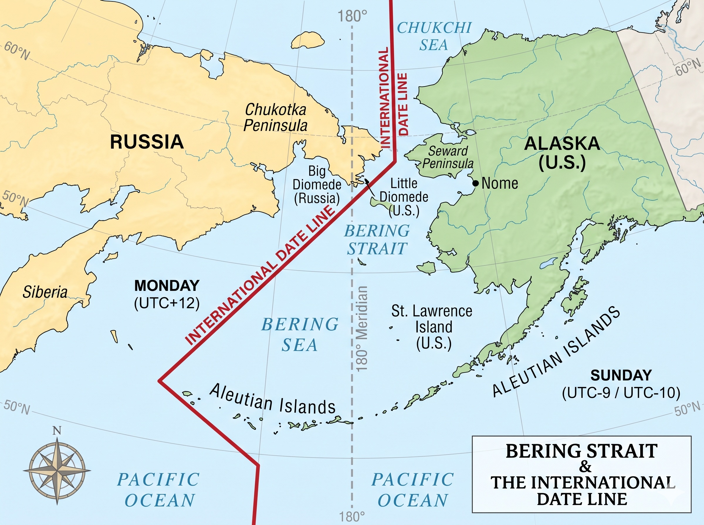
International date line time zone
UTC−12:00 is an identifier for a time offset from UTC of −12:00. It is the last to enter a new year and is sometimes referred to as the International Date Line West time zone (IDLW).
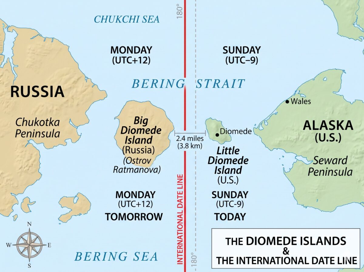
Diomede Islands in the International Date Line
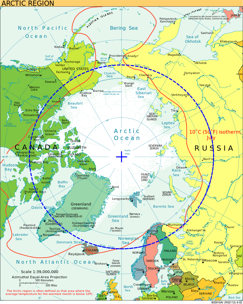
International date line and Arctic Circle
The Arctic circle is close to 16,000 km and the area north of the Circle is roughly 20,000,000 km2 which covers almost 4% of Earth’s Surface.
The Arctic is derived from the word “arktikos”, which means bear in the Greek language. The “Ursa Major” Constellation is viewed in the Northern sky. The Arctic Circle region, where at least 1 day a year will receive sunshine all day during summer and the full one day or 24 will not receive any light and will be dark throughout the day.
The Arctic Circle passes through the Arctic Ocean, the Scandinavian Peninsula, North Asia, North America, and Greenland.
The countries in the Arctic Circle are eight; they are Norway, Sweden, Finland, Russia, the United States, Canada, Denmark, and Iceland.
IDL also separates Russia and the US off Alaska’s West Coast.
The Big Diomede Islands in Russia and Little Diomede in the USA are apart by 3.8 Km of the sea, and IDL runs midway between them.
The Arctic and Antarctic Circles are the parallels of latitude that are roughly 66.5 degrees (66° 33′ 44″ (or 66.5622°).
Arctic circle latitude
Arctic Circle, parallel, or line of latitude around the Earth, at approximately 66°30′ N. This is due to the Earth’s inclination of about 23 1/2° to the vertical. This marks the southern limit of the area within which, for one day or more each year.
As a result, the Sun does not set (about June 21) or rise (about December 21).
FAQ
a. Where is the dateline located?
The dateline is located at the 0-degree longitude line in Greenwich, England. It was established in 1884 and passes through the mid-Pacific Ocean.
b.What is the longitude of the International Date Line?
It is 0-degree Longitude. It is the starting point.
c. Antarctic circle passes through which countries?
The only country that passes through the Antarctic Circle is Antarctica. But Antarctica is not a country; it is the southernmost continent.
Reference
- International Date Line | Definition, Map, Importance, & Facts | Britannica
- International Date Line – Wikipedia
- https://www.britannica.com/place/Arctic-Circle
