Endogenic and exogenic forces upsc

The endogenic and exogenic forces cause physical stresses and other chemical actions on the earth’s materials and bring changes to the surface of the earth. This is known as the Geomorphic process.

Endogenic and Exogenic forces

  • The forces which work over the surface of the earth are called Exogenic forces and the forces that work inside the surface of the earth or which act interior of the earth are called Endogenic forces.
  • The endogenic forces work is visible only after it causes sudden damage or severe damage. Still, on the other hand, exogenic forces create visible changes as these changes took hundreds or thousands of years.

The Endogenic processes are diastrophism and volcanism and the exogenic process is Weathering, mass wasting, erosion, oxidation, reduction, hydration and deposition. The exogenic process also depends on the climate, type and structure of the rocks.

Geomorphic agents are water, ice, wind etc. These agents remove materials and transport them over the slope and deposit them at a lower level.

Geomorphic Processes Weathering
Geomorphic Processes Weathering By Wing-Chi Poon (talk · contribs) – Own work, CC BY-SA 2.5, https://commons.wikimedia.org/w/index.php?curid=391721

Gravity is the directional force that activates all the downslope movement and also causes stresses on the earth’s material. Indirect gravitational stresses activate wave and tide-induced currents and winds. Without the gradients and gravity, there will be no mobility and no erosion and deposition are possible.

All the movement inside or outside the surface of the earth happens due to gradients from the higher level to the lower level, and from high-pressure to low-pressure areas etc.

The five geomorphic processes of weathering are

The four types of physical weathering are due to water, ice, plant and animals. Similarly, chemical weathering is due to water dissolving minerals in the rock, producing a new compound.

For example: When water reacts with granite, the Feldspar crystal inside the granite reacts chemically forming clay minerals, which weakens the rock and makes it more vulnerable to Weathering.

Geomorphic Processes Weathering due to glacial transportation, glacial deposition and glacial erosion.

FAQ

  1. What are exogenic and endogenic forces?

The forces that act in the interior of the earth are called Endogenic forces. The forces that work on the surface of the earth is called Exogenic forces.

Geological time scale Upsc

Geological Time Division

It is the calendar of events of earth History. It is subdivided into eons, eras, periods, epochs and ages. It is used by Paleontologist, geologists to demonstrate the associations and timing of events.

Eons are the longest time division and ages is the shortest. The era we live in the Holocene epoch, Quaternary period, Cenozoic era and Phanerozoic eon.

90% of the earth’s history is made up of Precambrian time.

Geological time scale
By WoudloperDerivative work: Hardwigg – File:Geologic_clock.jpg, Public Domain, https://commons.wikimedia.org/w/index.php?curid=11926892

Periods of Geological time scale

  • Precambrian (650 to 550 million years ago)
  • Cambrian (550 to 500 million years ago)
  • Ordovician (500 to 450 million years ago)
  • Silurian (450 to 400 million years ago)
  • Devonian (400 to 350 million years ago)
  • Carboniferous (350 to 300 million years ago)
  • Permian ( 300 to 250 million years ago)
  • Triassic (250 to 200 million years ago)
  • Jurassic (200 to 150 million years ago)
  • Cretaceous (150 to 100 million years ago)
  • Quaternary (50 million years ago to Present)

Geological Time scale with Events

Precambrian

It is the earliest geologic age. It is marked by different layers of sedimentary rocks that are laid over millions of years and these rocks contain a permanent record of the earth’s past such as fossils of plants and animals.

Cambrian

It is the first geological period of the Paleozoic era which is known as a time of ancient life. This period saw the burst of the incredible diversity of life that includes many animal groups that are present today.

One such are chordates from which vertebrates arrived.

Ordovician

This period is known for its diverse marine invertebrates that include graptolites, trilobites, etc. In this period, a rich variety of marine life flourished and the first primitive plants began to appear on land before the mass extinction ended this period.

Silurian

The Silurian period was known for many biologically important events such as widespread radiation of crinoids in the oceans, expansion of brachiopods, a continued proliferation, and also oldest known coral reef found belonged to this age.

The animals that lived in this period are bryozoans, crinoids, clams, cephalopod, jelly, sea scorpion (Pterygotus), brachiopod, jawless fish (Birkenia), gastropod shell, brittle star, trilobite, bivalve mollusc, sponges, sea star, etc

Devonian

The Devonian Period is known for the Age of fishes, as in this Geological time scale variety of fishes flourished. Some of the examples are armoured placoderms.

Other animals are the Earliest Arachnids, brachiopods, crinoids, other echinoderms, rugose coral, etc are common animals that flourished during this period.

Carboniferous

It is characterized by dense and swampy forests that gave rise to huge deposits of peat. The peat is transformed into rich coal stores in Europe and North America.

The animals that lived during the Carboniferous Period are Primitive amphibians, reptiles, spiders, scorpions, etc.

The major during this period are shifting of continents due to which mountains are formed.

Permian

The Permian period is known for the greatest extinction of all time. The animals that lived during this time are Edaphosaurus, archosaurs, amphibians, fish, and invertebrates like insects, worms, etc.

Triassic

The Triassic period is known for the time of great change. The period saw huge shifts in the diversity of life on Earth. The major event of this period might be a volcanic explosion, climate change, or being hit by a comet or asteroid that triggered the extinction of more than 90% of the earth’s species.

Jurassic

The Jurassic period is known as the fauna that transition from the Triassic fauna. It is dominated by both dinosauromorph and pseudosuchian archosaurs.

The first birds appeared during this period.

Cretaceous

The Cretaceous is known for the animals now extincted such as marine reptiles, ammonites, rudist, and dinosaurs.

During this period new groups of mammals and birds appeared. Also, the flowering plants appeared.

The animals during this period are Ornithischians, iguanodon, Tyrannosaurus rex, etc

Quaternary

The Quaternary period is known for the glacial growth and extinction of many species and also the spread of humans.

It is ‘Age of Humans‘, Upright Man appeared in Africa during the starting of this period, and as the time evolved this creature went on become to rule the world.

Conclusion

Some of the major events in the geological time scale are the first appearance of life on earth, the formation of mountains, and the extinction of dinosaurs.

Interior of the Earth and its 3 Layers Upsc

Interior of the earth

The earth’s interior can only be understood by indirect methods, as no one has gone deep inside the earth, due to high temperature and pressure.

The surface of the earth is due to a number of processes that happen deep inside the earth. The surface of the earth is due to exogenic as well the endogenic forces that happen inside the earth.

The radius of the earth is 6370 km and nobody has ever reached the centre of the earth. The information which we have got today is all based on observation and analysis of materials.

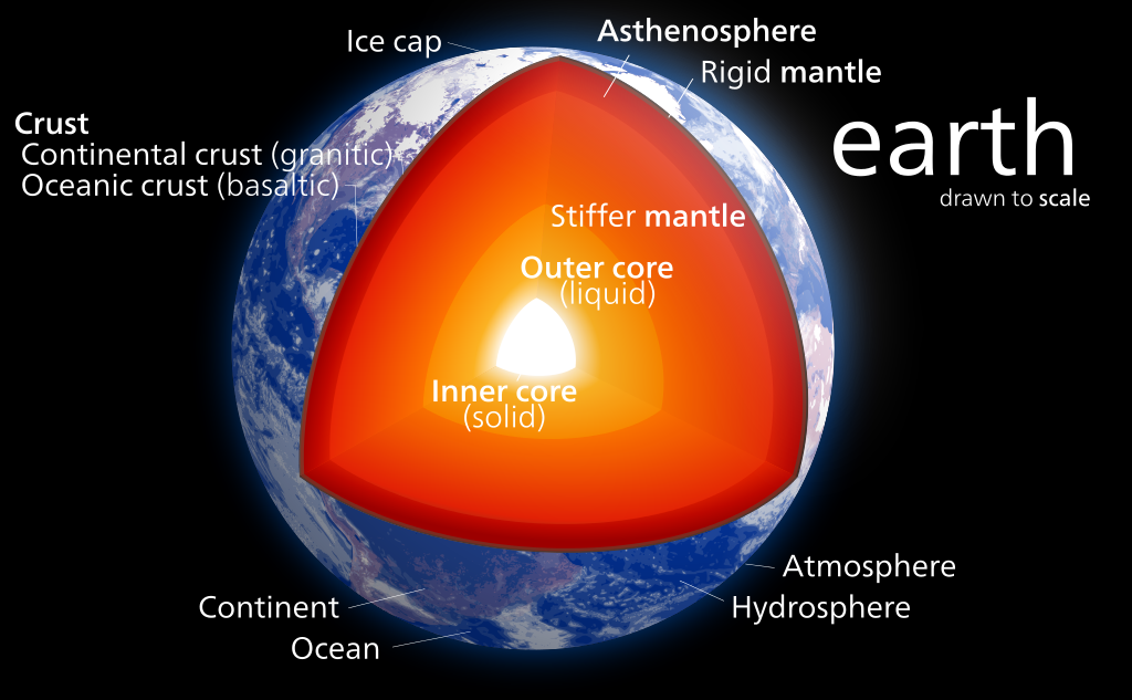
the interior of the earth diagram
Inside the Earth diagram By Kelvinsong – Own work, CC BY-SA 3.0, https://commons.wikimedia.org/w/index.php?curid=23966175

Inside the earth

The Interior of the earth consists of Crust, Mantle, and Core. The continental crust is made of Sial which is expanded as Silica and Al-alumina.

And Oceanic crust is made up of Sima which is expanded as Silicon and Magnesium.

The interior of the earth is extremely hot and reaches as high as 5000 degrees Celsius. This is probably because of two reasons. One is the heating when the earth is formed and the other is the heat from the decay of the radioactive elements.

Crust

The crust is the outermost part, and it is brittle. Its thickness varies from oceanic and continental areas. The crust in the oceanic region is thinner than the continental crust.

Its average thickness is 5km in the case of oceanic crust and its average thickness is 30 km in the case of continental crust.

The continental crust is thickest in mountainous regions. For example, the Continental crust is 70 km thick in the Himalayan region.

Mantle

The mantle is present after the crust. It extends from Moho’s discontinuity to a depth of 2900 km. The Mantle consists of a number of layers.

The upper layer of the Mantle is called Asthenospher that is extending up to 400km. The word Astheno means Weak. The lava comes through the Asthenosphere.

The crust of the uppermost part of the mantle is called Lithosphere and its thickness is about 10-200 km. The lower mantle extends beyond the asthenosphere which is in a solid-state.

Core

The Final layer of the Interior of the earth is the core. The core is located at the depth of 2900 km. The outermost core is in a liquid state and the innermost core is in a solid state.

The core is made of Nickel and Iron and due to it is also referred to as Nife Layer.

Cause of the interior of the earth to separate into layers

The earth is divided into layers because of gravity and density. The stratification of Earth into layers was the reason for the formation of the Earth’s iron core.

This Iron core is possibly formed by radioactive decay and strong gravitation. This might have caused high temperatures and made iron melt.

As the molten iron moved to the center of the Earth due to gravity and it displaced the materials that are less dense to the surface.

Study of Interior of Earth

Scientists study the interior of the earth by studying seismic waves. These are recorded by an instrument called Seismograph. As it is impossible to drill the center of the earth, scientists use indirect observation of the underlying matters below the surface.

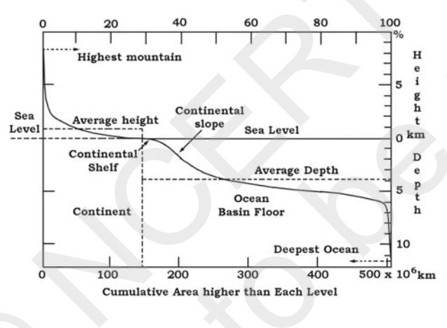
Ocean floor configuration and its major divisions Upsc

Ocean floor configuration

It helps in the know about the distribution of continents and oceans. the ocean floor is divided into three divisions based on its depth and as well the forms of relief.

The division is known as Continental Margin, deep-sea basin and mid-ocean ridges. The Ocean floor configuration

Continental Margins

Continental Margins are the transition between the continental shores and deep-sea basins. These include a continental shelf, continental slope, continental rise and deep oceanic trenches.

The deep oceanic trenches are one which is interesting part with respect to the distribution of oceans and continents.

ocean floor configuration
Ocean floor configuration

Abyssal Plains

Abyssal Plains are extensive plains that lie between the continental margin and mid-oceanic ridges.

These are the areas where the continental sediments are deposited.

Mid Oceanic Ridges

Mid oceanic Ridges are an interconnected chain of mountains system under the ocean. These are the longest mountain chain on the surface of the earth, which are submerged under the ocean.

It is characterized by a central rift system at the crest, a fractionated plateau and a flank zone all along its length.

The volcanic activity zone occurs in the crest of the rift system.

Fractionated plateau and Flank zone

Fractionated plateau

Flank zone

  • The flanks are market by set of mountain and hills, which are elongated and parallel to the ridge trend.

Crop calendar Tamil Nadu and its Planting Seasons

Crop calendar Tamil Nadu

Planting Seasons in Tamil Nadu is classified into 8 types. They are:

  1. Navarai
  2. Sornavari
  3. Kar
  4. Kuruvai
  5. Early Samba
  6. Samba
  7. Late Samba/Thaladi/Pishanam/Late Pishanam
  8. Late Thaladi

The crop calendar in Tamil Nadu is classified into 8 based on the Month of Sowing, Duration or Day. This duration is classified into Short duration, Medium and Long duration.

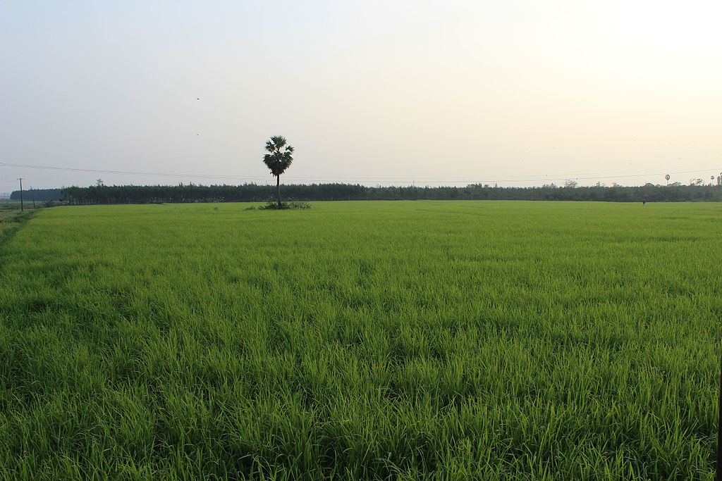
Tamil Nadu basically cultivated Paddy as main crops. Based on which the seasons are named.

Crop calendar Tamil Nadu
Crop calendar Tamil Nadu By KARTY JazZ – Own work, CC BY-SA 4.0, https://commons.wikimedia.org/w/index.php?curid=54442353

Navarai

The month of Sowing is December to January. The Duration of the crop is less than 120 days.

Short duration varieties are sown. Varieties sown in Navarai are ADT 36, ADT 37, ASD 16, IR 64, ASD 18, ADT 42, ADT 43 MDU 5, ASD 20, etc.

The districts of cultivation are Tiruvallur, Vellore, Tiruvannamalai, Cuddalore, Villupuram, Tiruchirapalli, Perambalur, Karur, Nagapattinam, Madurai, Theni, Salem, Namakkal, Dindigul, Dharmapuri, Coimbatore, Erode, and Pudukkottai districts.

Sornavari

The month of Sowing is April to May.

The Duration of the crop is less than 120 days.

Short duration varieties such as

The districts of cultivation are Tiruvallur, Vellore, Tiruvannamalai, Cuddalore, Villupuram, Namakkal, and Dharmapuri districts.

Varities sown during Somavari are IR 64, ADT 36, IR 50, ADT 37, ASD 16, ASD 17, ASD 18, ADT 42, MDU 5, ASD 20, ADT 43, CO 47, ADT (R) 45, ADT RH1, ADT (R) 47, etc.

Kar

The month of Sowing is May to June. The Duration of the crop is less than 120 days.

Short duration varieties such as:

The districts of cultivation are Tirunelveli, Kanyakumari, Tuticorin, Erode, Coimbatore, Madurai, Theni, Dindigul, Salem, Namakkal, and Dharmapuri districts.

Varieties of paddy sown during Kar are ADT 36, IR 50, IR 36, IR 64, ADT 37, ASD 16, ASD 18, ADT 42, MDU 5, ASD 20, ADT 43, CO 47, ADT (R) 45 (Dindigul only), TRY (R) 2*, ADTRH 1, ADT (R) 47, etc.

Kuruvai

Kuruvai is also known as ‘Short Term’ in Tamil Nadu. The crops are grown in Tamil Nadu in Cauvery Delta.

The month of Sowing is June to July. The Duration of the crop is less than 120 days.

The districts of cultivation are Tiruchirapalli, Perambalur, Karur, Thanjavur, Nagapattinam, Tiruvarur, Pudukottai and Erode districts.

Varieties of paddy sown during Kuruvai are ADT 36, IR 50, IR 64, ASD 16, ADT 37, ASD 18, ADT 42, MDU 5, ADT 43, CO 47, ADT (R) 45 (except Karur), TRY (R)2*, ADTRH 1, ADT (R) 47, etc.

Early Samba

The month of Sowing is July to August. The Duration of the crop is less than 130 to 135.

Medium and Long during varieties of Paddy are sown.

The districts of cultivation are Tiruvallur, Vellore, Tiruvannamalai, Salem, Namakkal, Cuddalore, Villupuram, Madurai, Theni, Ramanathapuram, Dharmapuri, Coimbatore, Erode, Pudukkottai, and Nilgiris districts.

The Varieties of paddy sown during Early Samba are IR 20, White Ponni, CO 43, Ponmani, PY 4, ADT 38, TRY 1, ASD 19, ADT (R) 44, CORH 2, etc.

Samba

The month of Sowing is August. The duration of the crop is 130 to 135 days and less than 150 days.

Medium and long-duration varieties are sown. All the districts cultivate it.

The Varieties of paddy sown during Samba are Ponmani, ADT 40, Bhavani, IR 20, White Ponni, CO 43, Paiyur 1, PY 4, CO 45, TRY 1, ASD 19, CORH 2, etc.

Late Samba/Thaladi/Pishanam/Late Pishanam

The month of Sowing is September to October. The duration of the crop is 130-135 days.

Medium and long-duration varieties are sown. The districts of cultivation are Tiruvallur, Madurai, Theni, Coimbatore, Erode, Dindigul, Kanyakumari, Tirunelveli, and Tuticorin districts.

The Varieties of paddy sown during late Samba are ADT 38, IR 20, CO 43, Ponmani, ADT 39, TRY 1, ASD 19, ADT (R)46, etc.

Late Thaladi

The month of Sowing is October to November.

The duration of the crop is 115-120 days.

Medium and long duration varieties are sown.

The districts of cultivation are Thanjavur, Nagapattinam, Tiruvarur, Tiruchirapalli, Perambalur and Karur districts.

The Varieties of paddy sown during late Thaladi are ADT 38, IR 20, CO 43, Ponmani, ADT 39, TRY 1, ASD 19, ADT (R)46, etc.

Conclusion

We have discussed Crop calendar tamil nadu, the season, its respective months, life time of crops and also the varieties of paddy cultivated during the various seasons across the districts of Tamil Nadu.

Savanna food web, chain, ecosystem and its biome

Savanna food web

The Primary consumer in the Savanna food web is Zebras and elephants. The Secondary consumers are cheetahs, hyenas, etc. The Scavengers here are vultures, hyenas, and termites. The reason hyena is present in both Secondary and Scavenger is because it gets their food by hunting in groups and also Scavenging on dead animals.

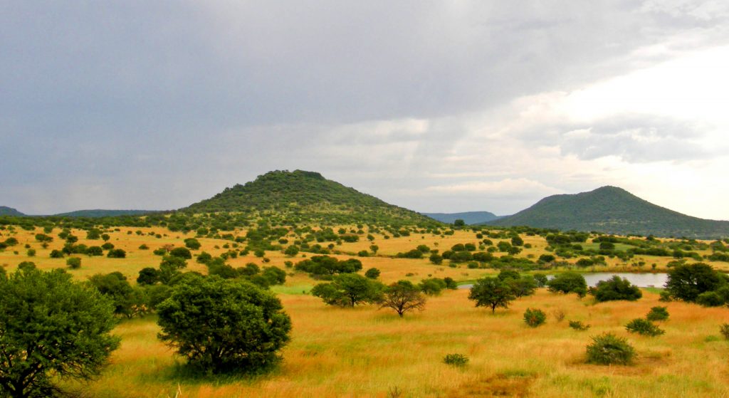
In this biome, Tall grasses are dominant and are the primary producer. The tall grasses convert energy from the Sun and minerals, and nutrients from the soil into the biomass that forms the basis of this Food Web. One of the important examples savanna food web is the one that exists in Africa.

African savanna food web

In the African savanna food web, the savanna is essential and it is a treeless plain present in a tropical or subtropical area, which is grassland found in eastern Africa, and the Northern part of Southern America.

It generally consists of scattered trees and drought-resistant flora. Some of the famous savannas are the Serengeti Plains of Tanzania, the Acacia Plains of East Africa, the savannas of Venezuela, the Sahel, south of Sahara in East Africa, and the Australian Savanna.

These tropical grasslands are found between tropical forests and deserts. This biome is found between 10° to 20 ° N and S latitudes.

These are generally hot and dry and experience moderate to low rainfall. As a result of this climate, the grasses grow tall and sharp. The chief occupation of people living here is herding and basically, these are Nomadic.

The biggest threat to the Tropical savanna food web is human activities such as converting these biomes to Pastoral lands, Agricultural activities, over-grazing, livestock, logging, and the introduction of non-native plants, etc.

The types of savannas are Tropical and Subtropical Savannas, Temperate Savannas, Mediterranean Savannas, Flooded Savannas, and Montane Savannas.

It is referred to by different names around the world such as:

  • Pampas in South America
  • Pasture,
  • Prairie in Northern America,
  • Rangeland in the USA
  • Steppe in Eastern Europe and Central Asia
  • Veld in Africa.
  • Downs in Australia
Tropical savanna food web
Tropical savanna food web by Gossipguy, CC BY-SA 3.0 https://creativecommons.org/licenses/by-sa/3.0, via Wikimedia Commons


Food chains in the savanna

The Zebras and elephants graze on grasses. The Lion and cheetah eat Zebras. Mara eats pampas grass and Maned Wold hunts Mara. The Hyena hunts as well as scavenges.

There are Vultures, and termites, in Savanna that are also Scavengers. The decomposers or Detritivores are mushrooms, insects, and microorganisms.

To Summarise the Food chains in the savanna: Producers, Primary consumers, Secondary Consumers, and Scavengers.

Producers in the Savanna

The primary producers in a savanna represent a complex functional group consisting of species of different habitats, sizes, and physiological requirements. The subdivision of the primary producers into morphological types such as herbs and trees.

The herbs can be further separated into grasses and forbs, C3 and C4 photosynthetic types, nitrogen-fixing and non-fixing, deep and shallow-rooted, early and late growers and so on.

The functional group of plants is defined according to the habit and size. In Savanna ecosystems, it is vital to differentiate between Herbaceous and Ligneous plants. This is because there are plants related to different rates of organic matter production and accumulation.

The producers in the Savanna include Grass, Acacia Trees, baobab Trees etc. Here also people cultivate pearl millet, legumes, vegetable crops, fonio, African rice etc.

Primary consumers in the Savanna

Primary Consumers of the savanna or the Herbivores in Savannas comprise vertebrates and invertebrates. The vertebrates that are well known are the large native mammals – animals of browsers and grazers, which is a salient feature of many African Savannas.

Also, there are many smaller herbivorous animals in Savannas including Armadillos and porcupines. Although invertebrates such as grass-eating harvester termites are important features of savannas.

The termites, ants, and grasshoppers are neglected as components of the savanna yet these insect herbivores play an important role in the savanna process including consuming grass material and seed predation.

Primary consumers in the savanna are Ostrich, Zebra, Thomsons Gazelle, Grasshopper, Giraffes, Elephants, etc.

Secondary Consumers

Savanna’s secondary consumers are Lions, Cheetahs, Secretary Birds, Harrier Eagles, etc. Human is also part Savanna food chain and they compete with other organisms for food.

Scavengers

Scavengers in the savanna are Hyenas, vultures, detritivores or decomposers like Fungi, bacteria, other Microorganisms, termites, etc. Also, Black-backed Jackals are seen on the hunting grounds of a lion.

Sometimes the top predators like lions also scavenge food.

Decomposers

Like any other ecosystem, decomposers in the savanna play a very important role in the flow of energy. The decomposers such as Bacteria, Fungi, Earthworms, and Insects do the role of transferring the energy between producers and consumers.

Bacteria in Savanna

Bacteriareis great number colonize the savanna’s soil. The bacteria in the savannas sustain well where the temperature is above 25 degrees Celsius.

Also, bacteria such as Acidobacteria are immune to changes in the moisture of the soil. This Acidobacteria slows down when the soil has few nutrients left adaptation makes them survive in the Savannas.

The most prominent bacteria in the African Savannas are Proteobacteria, Actinobacteria, Acidobacteria, Bacteroidetes, Chloroflexi, Firmicutes, Gemmatimonadetes, Planctomycetes, and Verrucomicrobia.

Fungi

The soils in Savanna are poor in nutrients, have frequent droughts and are very acidic. Due to these harsh conditions, fungi are less distributed than bacteria.

The common fungi found in African savannas are Sarcoscypha dudleyi, Laetiporus sulphureus, and Trametes versicolor.

Conclusion

We have discussed the savanna food web such as its basis of the food chain, What eats what in this biome what this biome is its reasons for its dangerous future, and the names it is called around the world.

References

  1. What Are the Trophic Levels in the Savanna? (sciencing.com)

North east monsoon in India Upsc

North east monsoon in India

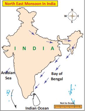
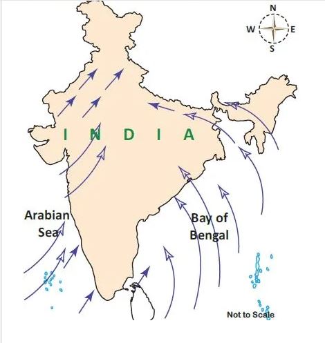
North east monsoon in India is also called as Post Monsoon or Retreating Monsoon. The southwest monsoon starts in North India by the end of the second half of September because of the southward shifting of pressure belts. This wind gets backs from the Indian peninsula and blows towards the Bay of Bengal.

The Coriolis forces deflect this wind and make this wind blow from the Northeast and it is known as North-East Monsoon or Post Monsoon season. The Northeast Monsoon in India is connected with the formation of the North-Easterly wind system over the Indian subcontinent.

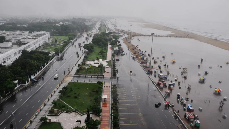
From this season, the states such as Tamil Nadu, Andhra Pradesh, Kerala, and south interior Karnataka get good rainfall that almost 35% of its annual rainfall. The Retreating monsoon creates a large-scale loss of life during the storms that occur frequently in Tamil Nadu, Andra Pradesh, and some parts of Karnataka.

During these seasons, strong winds and storms hit the coastal regions, and the daytime temperature falls rapidly all over the country. The average temperature over North-west India shows a decreasing trend from 38 and falling to 28-degree celsius in November.

North east monsoon in india
North east monsoon winds in india map

Ncert Notes for Retreating Monsoon

The below notes from 11th book

Season of Retreating Monsoon

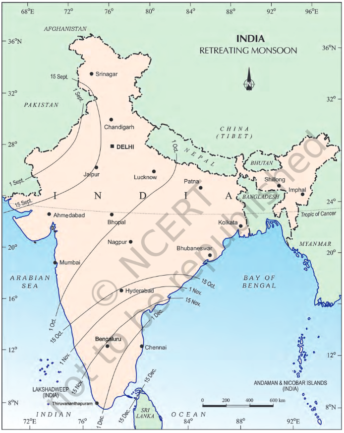
The months of October and November are known for retreating monsoons. By the end of September, the southwest monsoon becomes weak as the low pressure trough of the Ganga plain starts moving southward in response to the southward march of the sun. The monsoon retreats from the western Rajasthan by the first week of September.

It withdraws from Rajasthan, Gujarat, Western Ganga plain and the Central Highlands by the end of the month. By the beginning of October, the low pressure covers northern parts of the Bay of Bengal and by early November, it moves over Karnataka and Tamil Nadu. By the middle of December, the centre of low pressure is completely removed from the Peninsula.

The retreating southwest monsoon season is marked by clear skies and rise in temperature. The land is still moist. Owing to the conditions of high temperature and humidity, the weather becomes rather oppressive. This is commonly known as the ‘October heat’. In the second half of October, the mercury begins to fall rapidly, particularly in northern India. The weather in the retreating monsoon is dry in north India but it is associated with rain in the eastern part of the Peninsula. Here, October and November are the rainiest months of the year.

The widespread rain in this season is associated with the passage of cyclonic depressions which originate over the Andaman Sea and manage to cross the eastern coast of the southern Peninsula. These tropical cyclones are very destructive.

The thickly populated deltas of the Godavari, Krishna and Kaveri are their preferred targets. Every year cyclones bring disaster here. A few cyclonic storms also strike the coast of West Bengal, Bangladesh and Myanmar. A bulk of the rainfall of the Coromondal coast is derived from these depressions and cyclones. Such cyclonic storms are less frequent in the Arabian Sea.

————————————————–
————————————————–

Below notes are from Ncert 10th book

Retreating/Post Monsoons (The Transition Season)

During October-November, with the apparent movement of the sun towards the south, the monsoon trough or the low-pressure trough over the northern plains becomes weaker. This is gradually replaced by a high-pressure system. The south-west monsoon winds weaken and start withdrawing gradually. By the beginning of October, the monsoon withdraws from the Northern Plains.

The months of October-November form a period of transition from hot rainy season to dry winter conditions. The retreat of the monsoon is marked by clear skies and rise in temperature. While day temperatures are
high, nights are cool and pleasant. The land is still moist. Owing to the conditions of high temperature and humidity, the weather becomes rather oppressive during the day.

This is commonly known as ‘October heat’. In the second half of October, the mercury begins to fall rapidly in northern India.

The low-pressure conditions, over north-western India, get transferred to the Bay of Bengal by early November. This shift is associated with the occurrence of cyclonic depressions, which originate over the Andaman Sea. These cyclones generally cross the eastern coasts of India cause heavy and widespread rain. These tropical cyclones are
often very destructive.

The thickly populated deltas of the Godavari, the Krishna and the Kaveri are frequently struck by cyclones, which
cause great damage to life and property. Sometimes, these cyclones arrive at the coasts of Odisha, West Bengal and Bangladesh. The bulk of the rainfall of the Coromandel Coast is derived from depressions and cyclones.

north east monsoon winds in india map
North east monsoon winds in India map

Distribution of Rainfall

Parts of western coast and northeastern India receive over about 400 cm of rainfall annually. However, it is less than 60 cm in western Rajasthan and adjoining parts of Gujarat, Haryana and Punjab. Rainfall is equally low
in the interior of the Deccan plateau, and east of the Sahyadris. Why do these regions receive low rainfall? A third area of low precipitation is around Leh in Jammu and Kashmir. The rest of the country receives moderate rainfall.
Snowfall is restricted to the Himalayan region.

Owing to the nature of monsoons, the annual rainfall is highly variable from year to year. Variability is high in the regions of low rainfall, such as parts of Rajasthan, Gujarat and the leeward side of the Western Ghats. As such, while areas of high rainfall are liable to be affected by floods, areas of low rainfall are drought-prone.

Conclusion

The North East Monsoon is a crucial aspect of India’s climate system, bringing much-needed rainfall to southern peninsular India. Understanding its dynamics and impact is essential for various sectors like agriculture, water resource management, and disaster preparedness. For UPSC aspirants, a thorough grasp of the North East Monsoon is vital, as it is frequently tested in the geography and general studies papers.

Downloads

1.North East Monsoon in India Upsc 10th Ncert Notes Pdf

2.North East Monsoon in India 11th Ncert Notes for Upsc Pdf

The direction of South west monsoon in India

Direction of South West monsoon in India

The Bay of Bengal wind moves to northeast India, Myanmar and this wind is trapped by mountain groups such as Khasi, Garo, and Jaintia. This results in the heaviest rainfall in the world, that is Mawsynram located in Meghalaya.

Then it moves to the west, which results in a rainfall decrease from east to west. The southwest monsoon winds in India are responsible for 75% of the Indian rainfall. Tamil Nadu that is located on the leeward side receives less rainfall from this wind.

South west monsoon in India

There occurs a rapid increase of temperature in May over the North-Western plains. This intensifies the low-pressure condition over there.

By early June, this low pressure is enough to attract the trade winds of the Southern Hemisphere, which come from the Indian Ocean.

These Southeast trade winds cross the equator and enter the Bay of Bengal and Arabian sea and catch up in the air circulation over India.

These pass over the equatorial warm currents and bring a lot of moisture. This wind after crossing the equator follows a southwesterly direction. That is the reason it is called Southwest Monsoons.

Rain of Southwest Monsoon starts abruptly. The first result of this rain is it brings down the temperature quickly. This sudden onset of moisture-laden winds is associated with violent thunder and lightning. This is termed as ‘break’ or ‘burst’ of the monsoon.

The burst of monsoon starts in the first week of June in the coastal areas of Kerala, Karnataka, Goa, and Maharashtra. In the internal part of the country, the burst of monsoon gets delayed to the first week of July.

There would be a decline in day temperature from 5°C to 8°C between mid-June and mid-July.

When these winds approach the land, its southwesterly direction is changed by the relief and thermal low pressure over Northwest India. The southwestern monsoon approaches India by two branches:

  1. Arabian Sea Branch
  2. Bay of Bengal Branch

Monsoon Winds of the Arabian Sea

The Monsoon winds the starts over the Arabian sea further split into three branches:

First Branch

The first branch is obstructed by the Western Ghats. These winds get on to slopes of western ghats from 900-1200. Then they quickly become cool and as a result, the windward side of Sahyadris and Western Coastal plain gets heavy rainfall between 250 cm and 400 cm.

After crossing the western Ghats, these winds descend and get heated up and as a result humidity of these winds gets decreases. Due to this, the winds cause little rainfall in the east of the Western Ghats.

This region is called the Rain-Shadow region. This is because it receives less rainfall.

Second Branch

Another branch of Arabian sea monsoon winds hits the coast north of Mumbai. This moves along the Narmada and Tapi river valleys.

Then these winds cause rainfall in an extensive area of central India. As a result, the Chotanagpur plateau gets 15 cm of rainfall from this part of the branch.

At last, these winds enter the Ganga Plain and mingle with the branch of the Bay of Bengal.

Third Branch

The third branch of wind hits the Saurashtra Peninsula and Kachchh. Then it passes over Rajasthan and Aravalis and causes only a little rainfall.

In Punjab and Haryana, it joins the Bay of Bengal branch. These two branches reinforced and cause rains in the Western Himalayas.

Monsoon Winds of the Bay of Bengal

The Bay of Bengal branch strikes the coast the Myanmar and southeast parts of Bangladesh. The Arakan Hills on the coast of Myanmar deflect a big portion of the Bengal branch towards the Indian subcontinent.

Therefore the Monsoon enters West Bengal and Bangladesh from the south and southeast direction instead of the south-westerly direction.

From here, this branch splits into two under the influence of the Himalayas and the thermal low is northwest India. It’s one branch moves westward along the Ganga plains reaching up to Punjab plains.

Another branch moves up to Brahmaputra valley in the north and the northeast causing heavy rains.

Its subbranch strikes the Garo, Khasi hill of Meghalaya, Mawsynram that is located on the crest of Khasi Hills. This region receives the highest average annual rainfall in the world.

But during this season, the Tamil Nadu coast remains dry. This is due to two factors:

a. Tamil Nadu coast is situated parallel to the Bay of Bengal of southwest monsoon.

b. Also it lies in the rainshadow area of the Arabian sea branch of the southwest monsoon.

For Tnpsc

The southwest monsoon is the most important feature of the Indian climate. It takes place in the Southern Tip of India Peninsula normally by the first week of June.

South-West monsoon advances along the Konkan coast during starting of June and it covers the whole country by July 15.

The global phenomenon El Nino influences the South West Monsoon. In North India, the temperature reaches almost 46-degree Celsius before the southwest monsoon or rainy season.

There occurs a “Burst of Monsoon”, which is termed as Break, which is a sudden approach of monsoon wind over southern India with Thunder Showers.

This show reduces the temperature of the country.

south west monsoon in india
direction of southwest monsoon in india in map

South West Monsoon Winds

The monsoon wind that is the southern tip of India’s landmass gets separated into two branches.

One branch starts from the Arabian Sea and Another Branch starts from the Bay of Bengal. The one from the Arabian sea provides heavy showers to the west coast of India and is located on the west ghats windward side.

The other part towards the north hits the Himalayan Mountains and brings heavy rainfall in the North.

Rajasthan and western parts get rain from these winds as the direction of the wind is parallel to the Aravali mountains and there is nothing to hold or intrude the wind.

Theory of plate tectonics Upsc

Theory of plate tectonics

The theory of plate tectonics is a scientific theory that explains the formation of major landforms due to the Earth’s underlying movements. The Earth is often described as a living planet, which reshapes itself constantly through the forces that operate deep beneath the surface. Among these, the theory of plate tectonics is perhaps the most fundamental in explaining the Earth’s dynamic nature.

Plate Tectonics refers to the movement of large plates that make up Earth’s outer shell, and it is responsible for shaping continents, forming mountains, which fuels volcanic activity, and triggers earthquakes, etc.

What is the theory of plate tectonics?

The interest in the distribution of oceans and continents came to life after the introduction of the concept of seafloor spreading.

After that, it was McKenzie and Parker and also Morgan 1967 came out with another theory. This theory is based on a Lithospheric plate also called a Tectonic plate.

The tectonic plate is a massive, irregularly shaped block of solid rock and it is generally made of both continental and oceanic plates.

Their theory is collectively called Plate Tectonic theory.

Plate Tectonic theory

According to the theory of plate tectonics, the plates move horizontally over the Asthenosphere as solid units.

Plate Classification

The lithosphere consists of the crust and top mantle with a thickness of 5 to 100 km in oceanic parts and 200 km in continental areas.

Depending on the occupied area of the plate, the lithosphere is classified as an oceanic or continental plate.

  • If a large portion of the plate occupies the ocean it is called an Oceanic plate
  • If a large portion of the plate occupies the continent it is called a continental plate.
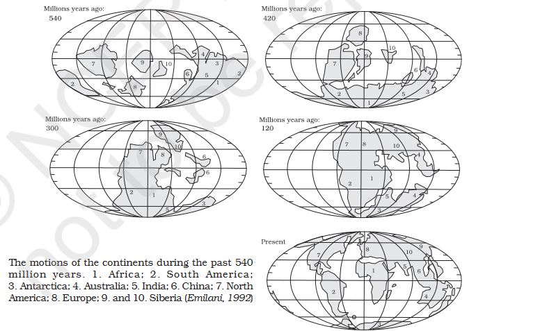
Plate tectonic theory
Plate tectonic theory – Position of continents through geological past Source:Ncert

An example of an Oceanic plate is the Pacific plate and the Continental plate is the Eurasian plate. According to this theory, the earth’s lithosphere is divided into seven major and some minor plates.

These plates are surrounded by Young fold mountain ridges, trenches, and faults. The major leaves are as follows:

Major and minor plates of the world

7 Major plates

The seven major plates of earth are:

  1. Antarctica and surrounding oceanic plates,
  2. North American Plate(with the western Atlantic floor separated from the South American Plate along with the Caribbean Islands),
  3. South American Plate (With the western Atlantic floor separated from the North American Plant along with the Caribbean islands),
  4. Pacific Plate,
  5. India-Australia-New Zealand Plate,
  6. Africa with the eastern Atlantic floor plate,
  7. Eurasia and the adjacent oceanic plate.

Above is the list of major plates. Now let us see the list of some important minor plates below:

  • Cocos Plate – It is found Between Central America and the Pacific plate
  • Nazca plate – It is found between South America and the Pacific plate
  • Arabian Plate – It is found in the Saudi Arabian landmass
  • Philippine Plate – It is found between the Asiatic and Pacific plate
  • Caroline Plate – It is found between the Philippine and Indian Plate that is North of Guinea
  • Fuji Plate – It is found in the North-East of Australia
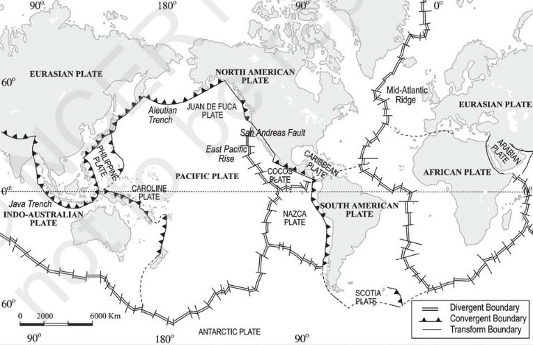
Tectonic Plates across the World in World map
Tectonic Plates across the World by Source: Ncert

These tectonic plates are dynamic, they keep moving on.

Wegner believed that the continents move by his Continental Drift Theory.

Alfred Wegner

But it is not, Actually, the continents reside over, the tectonic plates. It is the tectonic plates that actually move. And the fact is all the plates have moved in the past and will continue to move in future as well.

In the continental drift theory, Wegner believed that all the continents were once together as a single landmass called Pangaea. But later research revealed that these plates are wandering throughout geological history and Pangea was the result of the converging of different continental masses, which once were present somewhere else.

By using Palaeomagnetic data, the position of the current continental landmass is founded.

As per the data, the Indian subcontinent is traced with the help of rocks found in the Nagpur area.

The plate boundaries are of three types:

  1. Divergent Boundaries
  2. Convergent Boundaries
  3. Transform Boundaries

Divergent Boundaries

Whenever the plates move from each other, a new crust is generated. The spreading sites are sites where the plates move away from each other.

Example: the Mid-Atlantic Ridge divergent boundaries, as a result of the American plate, separated the front of the Eurasian and African Plates.

Convergent Boundaries

One plate dives under another where the crust is destroyed, Subduction zone is the location where the sinking of a plate occurs.

The convergence can occur in three ways, these are 1. Between an oceanic and continental plate; 2. between two oceanic plates; 3. between two continental plates

Transform Boundaries

Plates horizontally slide over each other, the crust is neither created nor destroyed. Transform faults are the planes of separation generally perpendicular to the mid-oceanic ridges.

The eruption does not take all along the entire crest at the same time, there is a differential movement of a portion of the plate away from the axis of the earth and also the earth rotation has effects on the separated block of the plate“.

Plate Movement Rate

The rate of the plate movement is determined by the strips of the normal and reverse magnetic fields that are parallel to the mid-oceanic ridges. Accordingly, the slowest plate movement rate is found in Arctic Ridge at less than 2.5cm/yr.

The fastest plate movement rate is found in the East Pacific rise near Easter Island in the south pacific about, west of Chile about 3400 km.

Plate Movement Force

When Alred Wegner proposed the Continental Drift Theory, most scientists believed that the earth was static and motion solid object but after various studies such as seafloor spreading, Plate Techtonic, etc, scientists found earth was continuously moving and dynamic. Now plate movement is accepted by everyone.

Below the Rigid plate, the mobile rock is believed to moving in a circular manner. The heated material is rise above, spreads, gets cooled and sinks to greater depths and this cycle is repeated continuously and called convection cell or convection flow.

The two main sources of heat within the earth are Radioactive decay and residual heat. This idea is first proposed by Arthur Holmes’s 1930s, later Harry Hess went about Seafloor Spreading.

The slow movement of the hot, softened mantle is responsible for the force behind the plate movement.

Also, Check the Indian Plate Movement

Conclusion

We have discussed Plate tectonic theory, Its types and the evidence that supports it. Also, we have discussed the Tectonic plates boundaries.

References

https://www.google.co.in/books/edition/Did_Plate_Tectonics_Give_Rise_to_Life_Un/KzMxEQAAQBAJ?hl=en&gbpv=1&dq=Theory+of+plate+tectonics&pg=PT11&printsec=frontcover

Continental drift theory Upsc

Continental drift theory

It is a Hypothesis, theory regarding the formation of the continents. When we look at the shape coastline of the Atlantic Ocean, the symmetry of the coastlines on either side of the ocean creates a curiosity in us.

This made many scientists think that the Two American continents, Europe and Africa were once together. This idea was first proposed by Abraham Ortelius, a Dutch mapmaker in 1596.

Continental drift theory was proposed by?

Continental drift theory was proposed by Alfred Wegener.

Also, A guy named Antonio Pellegrini drew a map, illustrating that the three continents were once together. But the comprehensive argument to support this theory was put by a German Scientist, Alfred Wegener. This theory was known as the Continental Drift theory. This theory was proposed in the year 1912.

Continental Drift Theory
Continental Drift Theory by nationalgeographic.org/encyclopedia/continental-drift/

According to Wegener, all the continents were once together as a single continental mass and it is surrounded by a mega ocean. He called this Mega continent ‘PANGAEA‘ and this mega ocean ‘PANTHA-LASSA‘.

Wegner argued that Pangaea began to split around 200 million years ago. Also that the super continental split into two large continental masses, one is Laurasia and another one is Gondwanaland.

Laurasia formed the northern component and Gondwanaland formed the southern part. Subsequently, these two continental masses broke into many pieces that we see today.

The best evidence for continental drift theory

The following is the evidence that supports the Continental drift theory by Alfred Wegener.

  • Jig-Saw-Fit
  • Rocks of Same Time across the continent
    • Tillite
    • Placer Deposits
    • Distribution of Fossils
  • Placer Deposits
  • Distribution of Fossils
  • Force for Drifting
  • Post-Drift Studies

Jig Saw Fit

Africa and South America’s shorelines have a great and unmistakable match. In 1964, Bullard produced the best fit for Atlantic margin using computer drawings, and it proved to be a great match. The match was tried at 1000 Fathom, deep in the sea.

Fathom

a unit of Fathom is equal to six feet (1.8 metres), mainly used in reference to the depth of sea, lakes etc.

Rocks of the Same Age across the continent

The Age of rocks is determined by radiometric dating methods across the continents and oceans. By this method belt of ancient rocks from the Brazil coast which is of age 2000 million years match those from Western Africa.

And the rocks from the Jurassic age, are found along the coastline of South America and Africa. These were the earliest marine deposits. This also suggests that the ocean did not exist prior to this age.

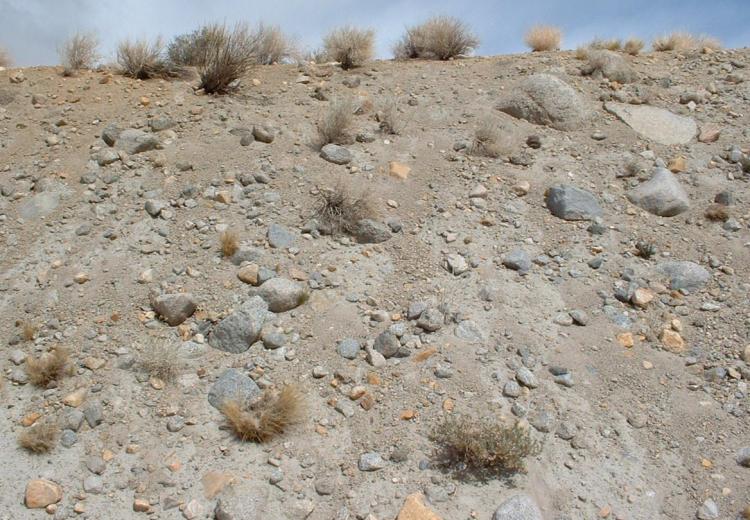
Tillite

Gondawana sediments from India has its counterparts in 6 different places in southern Hemisphere
Tillite (Gondawana) found in India and Parts of Southern Hemisphere – CC BY-SA 3.0, https://commons.wikimedia.org/w/index.php?curid=1320706

Tillite were the sedimentary rocks that are formed out of deposits of glaciers. A sedimentary rock that consists of consolidated masses of unweathered blocks such as large, angular, detached rock bodies and glacial till which are unsorted and unstratified rock material deposited by glacial ice in a rock flour.

Gondawana sediments from India and has their counterparts in six different landmasses of the Southern Hemisphere. At the base, the system has thick tillite indicating prolonged glaciation.

The Gondawana system of sediments from India was found in Africa, Falkland Island, Madagascar, Antarctica, and Australia.

The Glacial Tillite provides strong evidence of palaeoclimates and the drifting of continents.

Placer Deposits

Placer Deposits
Placer Deposits By © Hans Hillewaert, CC BY-SA 3.0, https://commons.wikimedia.org/w/index.php?curid=11750393

The presence of rich placer deposits of gold on the Ghana coast and the absolute absence of source rock in the region is an amazing thing.

The gold-bearing veins are in Brazil and are gold deposits of Ghana are derived from the Brazil plateau.

Distribution of Fossils

The same animal and plant fossils were found on different continents separated by thousands of Kilometres and the ocean between them is great evidence that the continents were once together.

Examples are Lemurs found in India, Madagascar and Africa linked to Lemuria landmass. These were separated by thousands of Kilometre and the ocean between them.

Also, Mesosaurus, an extinct marine reptile that has adapted to Brackish water, skeletons were found only in two places, are southern Cape province of South Africa and Iraver formation of brazil. The distance between these two locations is 4800 km and the ocean is in between them.

Force for Drifting

Alfred Wegners suggested that the movement of continents is due to tidal forces and polar-fleeing forces. Polar fleeing forces are forces created due to the rotation of the earth.

But the many scientists rejected this as these forces were very few.

Post-drift Studies

The post-World-II period and evolution of technology added new information to the studies. This includes information collected from the ocean floor mapping provided a new dimension for the study of the distribution of oceans and continents.

Conclusion

We discussed the Continental drift theory by Alfred Wegner and the evidence that supports this theory. This is useful for Upsc and other public service commission exams.

* * All the Notes in this blog, are referred from Tamil Nadu State Board Books and Samacheer Kalvi Books. Kindly check with the original Tamil Nadu state board books and Ncert Books.