The human population keeps increasing, exhaustible natural resources such as arable land, coral reefs, freshwater, fossil fuels, and forests continue to drop sharply.
This creates competitive demand for vital life-sustaining resources and contributes to an incredible decline in the quality of life.
Accelerated Habitat Loss
Overpopulation will increase the loss of ecosystems such as Wetlands, Wildlife, Rain forest, coral reefs, aquatic life forms, and grasslands.
Ex: Once 14% of the entire earth is covered with rain forest now it is only 6%.30% of ocean reefs are lost since 1980 due to acidification and global warming. More than half the original wetlands have been lost.
Amplified Climate Change and Global Warming – The more the number of people, the more the number of vehicles and industries would be. Furthermore, more population tends to increase the use of energy sources such as coal and firewood which contributes to increased greenhouse gas emissions.
Hence, because of the accumulation of human-generated greenhouse gases and carbon footprint in the atmosphere, the planet has continued to witness amplified global warming and climate change. The effects of climate change and global warming are resulting in extreme hunger, drought, flooding, and loss of habitat.
Loss of Biodiversity
Overpopulation has caused encroachment into frontier forests and destruction of natural ecosystems that have led to the mass extinction of species.
The number of threatened species persists to multiply in number whereas some have completely gone extinct. This is because of human activities such as acidifying water, overexploitation of natural resources, pollution, overfishing, poaching, and destruction of natural systems which are necessary for the survival of different species.
Decrease of fresh water
The unrelenting nature of overpopulation on the earth has destroyed most of the world’s fresh systems. Most of the lakes, streams, rivers, and groundwater making up freshwater have been polluted.
According to the global outlook of water resources, these activities influenced by overpopulation have only left less than 1% of the planet’s freshwater readily accessible for human utilization.
Water vulnerability is already affecting many overpopulated nations, especially in some developing countries, as the demands for water tend to be more than accessible water.
Millions of fish species from freshwater ecosystems are on the verge of extinction. Thus, as human inhabitants rise in number, so will the problem of quality freshwater accessibility.
Lower Life Expectancy and Diminished Quality of Life
Overpopulation lowers the standards of living since it creates stress on the vital resources for survival and increases the difficulty of accessing the consistent supply of quality food, water, energy, health, security, and shelter. Consequently, it makes the poor become poorer, and they often opt for poor living conditions to survive.
Eventually, it gives rise to lower life expectancy. The situation is serious in developing nations such as southern Asia and sub-Saharan Africa where most of the poor populations submit to inadequate and poor diets.
Rise in Unemployment, Crime Rate, and Violence
In overpopulated nations, the available job is fewer than the overall job-seeking population. This contributes to high levels of unemployment.
In turn, lack of unemployment leads to elevated crime rates because of theft, drug cartels, and militia groups which are exploited as options for attaining basic resources and necessities such as food, good living standards, and wealth.
Violence and conflicts arise when people start competing for the available limited resources.
Increased Intensive Farming
As the population has grown over the years, farming practices have evolved to produce enough food to feed larger numbers of people.
However, intensive farming methods also cause damage to local ecosystems and the land, which may pose problems in the future.
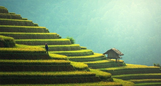
Irrigation is a method of providing water to crops by artificial methods. India is not only hot, there is seasonal and irregular rainfall.
To address these problems irrigation is important. Cultivation of annual crops continued high temperature, hydrophytes crops, porous soil, and commercial farming make irrigation essential.
Agriculture pattern & Cropping pattern in India
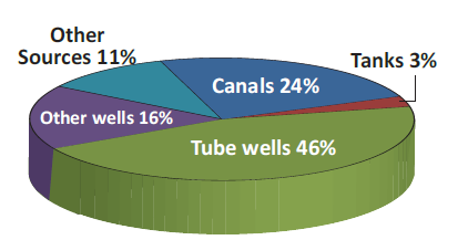
Sources of irrigation in India
The methods of irrigation change on location and various factors such as soil, rainfall, perennial and non-perennial river, ground availability, and nature of crops.
a)Canal Irrigation
Canal irrigation is one of the most important sources of irrigation. It accounts for about 24% of the total irrigation in the nation. It is an effective source of irrigation in low-level relief, deep fertile soil, and perennial river areas.
The total area under canal irrigation in India is 15.8 million hectares in 2014. 60% of Canal irrigation is found in the northern plains such as UP, Punjab, Haryana, Bihar, and Rajasthan.
Types of Canal Irrigation
There are two types of Canal Irrigation one is Inundation Canals and another one is Perennial Canals.
Inundation Canals
The water is taken out without any barrage and dam. Useful for diversion of flood and remains operational in the rainy season.
Perennial Canals
Most canal in India falls under Perennial Canals. By Constructing a barrage in the Perennial rivers.
b) Well Irrigation
About 62% of the net irrigated area in India is irrigated by Wells. Well, irrigation is cheap and dependable.
Well, irrigation is popular in areas where tank and canal irrigation is not available. There are two types of Well irrigation. One is Open Well and another one is Tube Well.
1.Open Wells
Open Wells is widely used where there is sufficient groundwater.
Ex: Delta regions of Cauvery, Krishna, Godavari, Mahanadi, and part of Tapti and Narmada Valleys.
2. Tube Wells
Tube wells are used in the areas where the water table is low and the surface is soft. Also drilled in hard rocky terrains.
Ex: Tamil Nadu, Madhya Pradesh, Punjab, and Maharashtra.
3. Tank Irrigation
Tanks are both natural and man-made. A hollow is built on the surface by constructing bunds across the stream, and canals. Tank Irrigation is an old system of irrigation in India.
The Tanks are used to collect water during the rainy season and store it for irrigation and other purposes. It includes Ponds and Lakes. Tank irrigation is popular in peninsular India.
It is popular in peninsular India due to the following reasons:
Hard to dig canals and wells in undulating relief and hard rocks.
Natural tank formations due to natural depression in the surfaces.
Perennial river absence in Peninsular regions.
No percolation in Impermeable rock structure.
People, Population and agricultural fields scattered in various areas.
Table: Leading State in Tank Irrigation
State
Area in Lakh Hectares(2013-2014)
1
Tamil Nadu
3.78
2
Andra Pradesh
3.40
3
Madya Pradesh
2.64
4
Telangana
2.3
5
Karnataka
1.54
States that use Tank Irrigation System
Modern Sources of irrigation
In India Drip, Poly House Central Pivot irrigation and sprinklers are used.
Drip system
Watering in drops near the root of the plant. Useful for Big trees and horticulture.
PER DROP MORE CROP(Improving water use efficiency) – Pradhan Mantri Krishi Sinchayee Yojana (PMKSY)
Micro Irrigation scheme sponsored by the Government of India to promote drip and sprinkler irrigation to save water.
Andra Pradesh, Maharashtra, Karnataka, Gujarat, and Tamil Nadu accounts for 78% of total micro Irrigation in the country.
Rain Gun
As the name suggests throw water like rain using a Water gun or rain gun. These sprinklers are used for crops having a height of 4 feet (1.22 m) or more.
For example Maize, Sugarcane.
Center-Pivot Irrigation or Central Pivot Irrigation
It is also called a Waterwheel or Circle Irrigation. This equipment has a sprinkler that rotates and waters the crops.
Multipurpose River Valley Projects
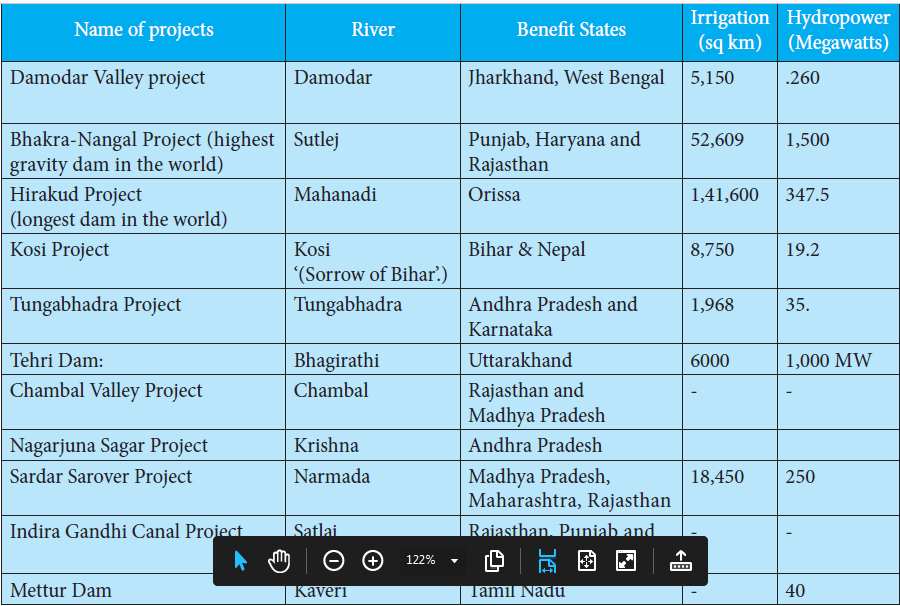
Management of water using scientific methods such as the construction of dams across rivers. Multipurpose river valley project is multipurpose applications such as the combination of Irrigation with Hydro Power Plants.
Also used for Controlling floods, fisheries, Industrial needs, Navigation, etc.
Table: Multipurpose River Valley Projects
Multipurpose River Valley Projects
Conclusion
The main sources of irrigation in India include Canals, Tanks, and Wells. Also in India, there are several other systems which include rainwater harvesting, dams, etc. The latest one is the drip irrigation system, which saves a lot of water.
FAQ
Tube well irrigation is highest in which state?
Uttar Pradesh State has the highest number of tube wells in India.
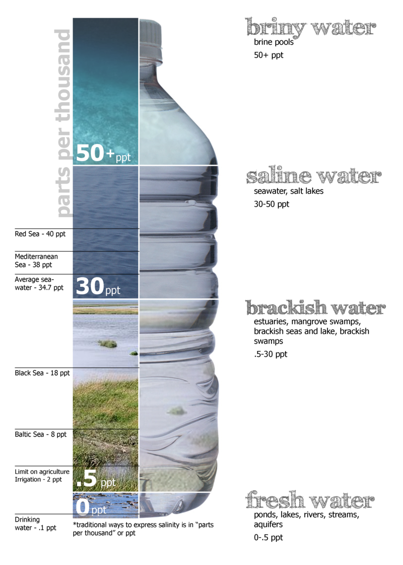
Every water in nature has dissolved mineral salts in it. Salinity is defined as the amount of salt in grams dissolved in 1 kg of seawater and it is usually expressed in Part Per Thousand (PPT).
The salinity of 24.7 PPT is considered as the upper limit to mark ‘brackish water’.
The saltiest place on earth
Lake Van (Turkey) – 330 PPT
Dead Sea (Jordan) – 238 PPT
Great Salt Lake (Usa) – 220 PPT
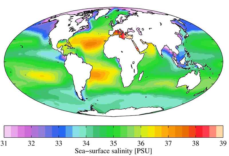
Salinity distribution of ocean by Source Wiki
Factors of Salinity distribution of ocean water
The salinity of water, in the ocean’s surface layer, depends on evaporation and precipitation.
The salinity of seawater in coastal regions depends on freshwater flow from rivers, in the polar regions due to the freezing and thawing of ice.
Sometimes wind also influences the salinity in a particular area by transferring water from one area to another area.
The Salinity distribution is influenced also due to ocean currents.
The salinity, temperature, and density of water are interrelated. Thereby any variation in the temperature or density influences the water’s salinity.
Horizontal Distribution of Salinity
The salinity for normal open ocean ranges between 33 PPT and 37 PPT and in the case of the landlocked Red Sea, it is as high as 41 PPT.
In the estuaries and the Arctic, the salinity fluctuates from 0-35 PPT, and in the hot and dry region, where the evaporation is high, the salinity reaches 70PPT.
The salinity in the Pacific Ocean is due to its shape and large area and the Salinity decreases from 35 PPT to 31 PPT in the western parts of the Northern Hemisphere due to the influx of melted water from the Arctic region.
Similarly, in 15° – 20° south, it decreases to 33 PPT and the average salinity of the Atlantic ocean is roughly 36 PPT.
The highest salinity is recorded between 15° and 20° latitudes and maximum salinity, 37 PPT, is recorded between 20° N and 30° N and 20° W – 60° W and its gradually decreases towards the north.
The North Sea, in spite of its location in higher latitudes, records higher salinity due to more saline water which is brought by the North Atlantic Drift.
Baltic sea records low salinity due to the influx of river water in huge quantity.
The Mediterranean sea records higher salinity due to high evaporation.
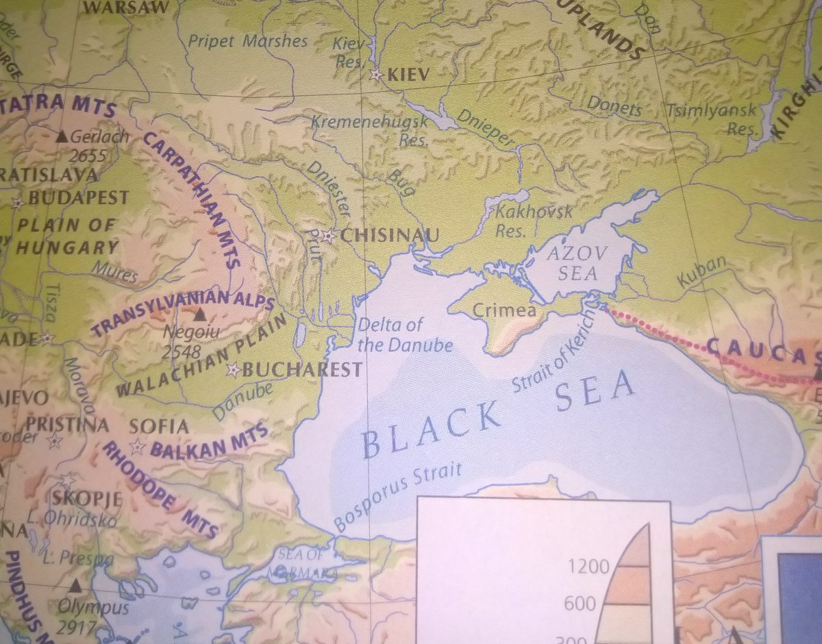
Salinity is very low in the Black Sea because of the enormous freshwater influx by rivers.
Danube, Dnieper, Don, Dniester, Kuban rivers drain into the Black Sea.
The average salinity, in the Indian ocean, is 35 PPT and low salinity is observed in the Bay of Bengal because of the influx of river water.
On the other hand, salinity in the Arabian sea is higher due to high evaporation and a low influx of freshwater.
Danube, Dnieper, Don, Dniester, Kuban rivers drains into Black Sea
Vertical distribution of salinity in ocean UPSC
Salinity also changes with depth, also the location influences it and the salinity at the surface of the sea depends on evaporation, loss of water, the influx of water, etc.
Salinity at the depth is fixed as there is no way water is added or removal is possible and there is a remarkable difference in salinity between the zone on the surface and zones on the depth.
The less salinity water stay above and more salinity water is at the depth.
Salinity generally increases with depth and there is a distinct zone called the Halocline, where the salinity increase sharply.
And other factors being constant, increasing the salinity of seawater causes its density to increase.
Highly salinity water generally sinks below the low salinity water and this phenomenon leads to stratification by salinity.
Types of soil in India with states & Soil distribution in India
Andhra Pradesh
Red Soil is 66% of the cultivated area and presents mostly in Rayalaseema districts. Black Soil covers almost 25%, it is present in the coastal district and part of Rayalaseema and Telangana.
Alluvial loamy clay soil covers 5% of the cultivated area found in Krishna and Godavari deltas. The coastal sands are only 3% and the remaining 1% is laterite soil.
Arunachal Pradesh
This state only has a 2% area for cultivation due to its pre humid ecosystem, elevated ridges, and intermontane valleys. Major types of soil are inceptisol, entisols, and ultisols. Alluvial soil found in river valleys is good for agriculture.
Crops grown here are Rice, Millet, Maize, Wheat, oilseeds, ginger, pulses, etc.
Assam
Assam has mainly four types of soil, they are Alluvial Soil, Piedmont Soil, Hill Soil, and Laterite soils. Alluvial soil is distributed over Brahmaputra and Barak Plain.
Piedmont Soils are confined to the northern narrow zone along the piedmont zone of Himalayan foothill and it comprises of Bhabar and Tarai soil that covers the Brahmaputra valley.
Hill Soils are found in the southern hilly terrains, this soil is classified as Red Sandy soil and Red loamy soils.
Laterite Soils were found over the N.C.Hills districts covering parts of southern Karbi Plateau, Karbe Anglong district, Golaghat district, and Barak Plain.
Bihar
The common soil in Bihar is Alluvium from the Indo-Gangetic plains. Piedmont Swamp soil found in the north-western part of the West Champaran district
Terai soil is found in the eastern part of Bihar along the border of Nepal. Other common soils found in Bihar are clay soil, sand soil, and loamy soil.
Chhattisgarh
Two types predominate the black, clayey soils and the red-to-yellow soils.
Entisols covers 19.5% cultivated area of the state, Inceptisols 14.8%, Alfisols 39%, Mollisols 0.3% and Vertisols 26.4%. Red soil is present in the eastern and southern parts of the Deccan Plateau.
Goa
The main soil of Goa is Coastal Alluvial soil, mixed red and black soil, laterite soil,and red sandy soil, which are sub-divided into 32 soil series.
The maximum thickness of laterite is observedalong the coast in the west and minimum along the Ghat section in the East.
The soils of Goa are mostly lateritic (81%). They are sandy loam to silt-loam in texture, well-drained, and highly acidic (5.5 to 6.5 pH).
Gujarat
The soils of Gujarat can be broadly classified into nine groups: black soil, mixed red and black soils, residual sandy soils, alluvial soils, saline/alkali soils, lateritic soils, hilly soils, desert soils, and forest soils.
The southern parts of the Gujarat plains show deep black soils. Central Gujarat possesses sandy loam soil, locally called Goradu.
Haryana
The soil type found in Haryana is alluvial. In Haryana, the soil is almost entirely formed of alluvium.
The soils are loamy sand to sandy loam on the surface and sandy loam to clay loam.
Himachal Pradesh
Major soil is brown hill soil, sub-mountain soils, mountain meadow soil, and red loamy soil.
The soil found in Shimla is general sandy loam. The crops cultivated are Wheat, maize, rice, barley, seed potato, mushrooms, olives, fig, etc.
Jharkhand
The soil of Jharkhand is five and they are Red Soil, Sandy Soil, Black soil, Laterite soil, and Red Micacious soil.
Sandy soil, is generally found in Hazaribagh and Dhanbad. The black soil, is found in the Rajmahal area. Laterite soil, is found in the western part of Ranchi, Palamu, and parts of Santhal Parganas and Singhbhum.
Red Soil is found in most parts of Jharkhand except in the basins of Damodar and in the Rajmahal areas.
Red micacious soil is mostly found in the mica regions such as Koderma, Mandu, etc.
Karnataka
Red soils: Red gravelly loam soil, Red loam soil, Red gravelly clay soil, Red clay soil.
Black soil: gravelly soil, loose, black soil, basalt deposits. Lateritic soils:
Lateritic gravelly soil, Lateritic soil.
Kerala
The soils of Kerala can be broadly grouped into coastal alluvium, mixed alluvium, acid saline, kari, laterite, red, hill, black cotton, and forest soils.
Madhya Pradesh
The major types of soils found in the state are Black soil, most predominantly in the Malwa region, Mahakoshal, and in southern Bundelkhand.
Red and yellow soil, in the Baghelkhand region. Alluvial soil, in Northern Madhya Pradesh.
Maharashtra
The soils of Maharashtra are residual, derived from the igneous basalts. The soil in the river basins of Godavari, Bhima, Krishna, and Tapi has a deep layer of fertile black basalt soil, which is rich in humus.
Manipur
The soil of Manipur belongs to 4 orders, 8 suborders, 13 great groups, and 23 subgroups. It is observed that the Inceptisols are the dominant soils followed by Ultisols, Entisols, and Alfisols and occupy 38.4%, 36.4%, 23.1% of the total geographical area of the State, respectively. Lake and marshy land occupy 1.9 percent.
Meghalaya
Meghalaya soils are rich in organic carbon, which is a measure of nitrogen supplying the potential of the soil, deficient in available phosphorous, and medium to low in available potassium. The reaction of the soils varies from acidic (pH 5.0 to 6.0) to strongly acidic (pH 4.5 to 5.0).
Mizoram
This state has sand loamy and clay loamy soil. It is rich in organic carbon and moderately rich in potash. Soil acidic range is 4.5-5.6 pH due to the high rainfall during May to September.
Nagaland
Nagaland soils are acidic, very rich in organic carbon but poor in available phosphate and potash content.
More than 66% of the land is Inceptisols. Its textures are fine clay, clay loamy, and fine loamy clay.
Odisha
Soil types range from fertile alluvial deltaic soils in coastal plains, mixed red and black soils in Central tableland, red and yellow soils.
Punjab
Punjab states soil are the clay, clay loam, sandy clay, silt clay, sandy clay loam, silty clay loam, sandy loam, silt loam, sand, loamy sand, and silt.
The soils are sandy loam to clay loam with light grey color to dark color, the structure is loose and more fertile. But the soils are low in NPK and humus.
Rajasthan
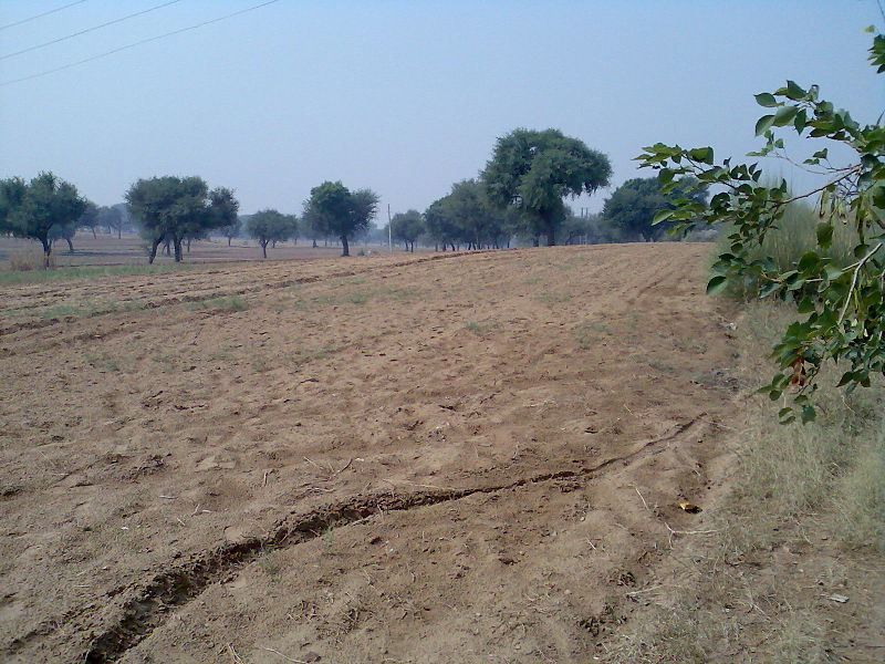
Rajasthan’s large area has desert soil, which covers the area west of the Aravallis up to the Pakistan border. The hilly tracts of the Aravali are characterized by the black, lava soils that sustain the growth of cotton and sugarcane.
Sikkim
Sikkim has well-drained coarse loamy, fragmental soils with brown to dark brown color, developed from sandstone parent rock.
The hills of Sikkim mainly consist of gneiss and schist which weather produce generally poor and shallow brown clay soils.
Tamil Nadu
The primary types of soil found in Tamilnadu are · Red soils, (62 percent) · Black soils (12 percent) · Laterite soils (3 percent) and · Coastal (7percent).
Telangana
Telangana contains various soil types, some of which are red sandy loams (Chalaka), Red loamy sands (Dubba), lateritic soils, salt-affected soils, alluvial soils, shallow to medium black soils, and very deep black cotton soils.
Tripura
The hills have red laterite soil that is porous. The flood plains and narrow valleys are overlain by alluvial soil, and those in the west and south constitute most of the agricultural land
Uttar Pradesh
Most of the area of Uttar Pradesh is covered by a deep layer of alluvium spread by the slow-moving rivers of the Ganges system. Those extremely fertile alluvial soils range from sandy to clayey loam. The soils in the southern part of the state are generally mixed red and black or red-to-yellow.
Uttarakhand
Uttarakhand has Quartzite soil; Volcanic soil; Brown soil; Alluvial soil; and Tertiary soil.
West Bengal
Soil found in West Bengal is Mountain soils, Alluvial soils, Red soils, and Saline soils.
Andaman and Nicobar Islands
The soil type of the Andaman and Nicobar Islands ranges from sandy clay to sandy loam. These have developed under the dominant influence of vegetation and climate over diverse parent material. The uplands under forest cover are intensely leached, but runoff is very high, wherever forest cover has been removed completely.
Chandigarh
The soils in UT Chandigarh are loamy sand at the surface and calcareous sandy loam in subsurface layers. The hard clay forms pan at depths varying between 20 and 30 m. In northern parts, the soil is sandy to sandy loam whereas it is loamy to silt loam in southern parts.
Dadra and Nagar Haveli
The Union Territory is having clay- loam type of soil, which is poor in drainage. The terrain of the south-eastern part is undulating to hilly and is shallow soil.
Daman and Diu
It is found that the soils of Dadra & Nagar Haveli are rich in Potash, medium in phosphorus, and medium to high in Nitrogen. Soil PH is 6.5-7.5.
Delhi
Delhi areas have mostly light with a subordinate amount of medium texture soils. The light texture soils are represented by sandy, loamy, sand, and sandy loam; whereas medium texture soils are represented by loam silty loam.
Jammu and Kashmir
The outer plains of Jammu are covered with Alluvial soils. The hilly and mountainous areas are covered with residual soils. Other Areas are covered with morainic soils.
Generally, the soil in J&K is loamy with little clayey soil that contains small amounts of lime with a high magnesium content.
Ladakh
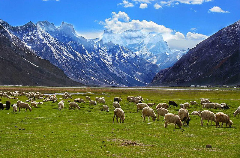
Soil in Ladakh Region By Narender9 – Own work, CC BY-SA 3.0, https://commons.wikimedia.org/w/index.php?curid=23815628
Soils in Leh and Kargil district are sandy to loam in texture, with medium to high in organic matter with poor water holding capacity. Wheat and barley are traditional crops of Ladakh, also cereals are grown for food and fodder.
The vegetation found here is Willow groves, Juniper yew, Wild roses, and herbs. Vegetables grown here are Potato, Peas, Onion, Cabbage, and Cauliflower. Apricots and apples are the main fruits of Ladakh and are widely grown in Sham, Nubra, and Kargil.
Lakshadweep
Lakshadweep soil types and crops cultivate By The.chhayachitrakar – Own work, CC BY-SA 4.0, https://commons.wikimedia.org/w/index.php?curid=60464005
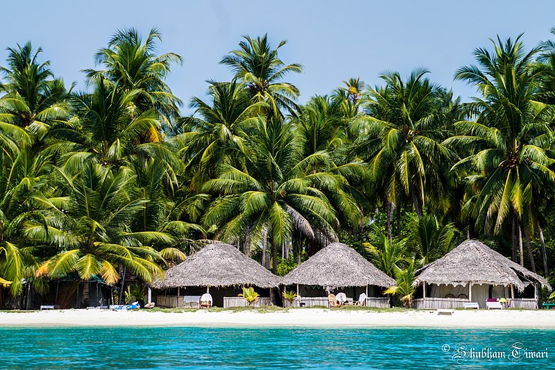
Lakshadweep is a group of Islands in the Arabian sea. It has a soil layer with overlying coral limestone. That is the soil in Lakshadweep is mainly derived from the coral limestones. It includes coral sands and lagoonal sands.
These soil are dominantly sandy soil that is formed by the physical weathering of coral limestones. This is because almost all the inhabited islands are coral atolls.
Main and probably only crop cultivated here is Coconut (Cacos nucifera). The varieties of coconut found here are Laccadive micro, Laccadive ordinary, green dwarf, etc.
Puducherry
The major area of the Union Territory is covered by Red soil of Sandy and Clay loam type. In some places, Ferruginous red soil is found. Along with the river courses, Alluvial soils are found. Also, Coastal Alluvium is all along the coast as a narrow belt.
The major food crops grown here are Rice, Ragi, Bajra, Pulses and cash crops grown here are cotton, groundnut, sugarcane, etc.
FAQ
1.Sandy soil is found in which state?
Sandy soil is mostly found in western Rajasthan, Southern Haryana, South-west Punjab, North-Western Gujarat and also along the east and west coast of India. In Goa, it is found in Salcete Taluk and towards the western Canacona taluk and also in Marmugao Taluk
2. Red soil states in India?
Tamil Nadu has the red soil in India. Red soil is also found in Southern Karnataka, North-Eastern Andra Pradesh and parts of Madhya Pradesh, Odisha and Chhattisgarh.
3. Alluvial soil found in which state?
The entire northern plains include Arunachal Pradesh, Assam, Bihar, Chandigarh, Delhi, Haryana, Madhya Pradesh, Himachal Pradesh, Punjab, Rajasthan, Uttar Pradesh, and West Bengal.
It is made of two chains of mountains that are separated by a large depression. It has peaked as high as 2500m and some even reach above the ocean surface.
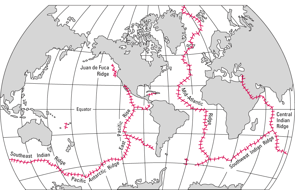
Distribution of Mid Ocean Ridges By J M Watson – USGS, U.S Geological Survey; http://pubs.usgs.gov/gip/dynamic/baseball.html, Public Domain, https://commons.wikimedia.org/w/index.php?curid=4575922
Mid oceanic ridge formation
It occurs along the divergent plant boundaries when a new floor is formed, due to earth tectonic plates spread apart, also called seafloor spreading. In the volcanic eruption, molten basalt comes out.
The speed of spreading of molten basalt affects the shape of the ridge. Faster spreading produces wider and more gentle slopes and slower spreading results in irregular steep topography.
Mid oceanic ridge location
Aden Ridge – Part of an active oblique rift system in the Gulf of Aden, between Somalia and the Arabian Peninsula
Explorer Ridge – mid-ocean ridge west of British Columbia, Canada
Galapagos Spreading Center – an east-west trending mid-ocean ridge east of the eponymous islands between the Nazca and Cocos plates
Gorda Ridge – tectonic spreading centre off the northern coast of California and southern Oregon
Juan de Fuca Ridge – A divergent plate boundary off the coast of the Pacific Northwest region of North America.
South American–Antarctic Ridge – Mid-ocean ridge in the South Atlantic between the South American Plate and the Antarctic Plate
Chile Rise – An oceanic ridge at the tectonic divergent plate boundary between the Nazca and Antarctic plates
East Pacific Rise – A mid-oceanic ridge at a divergent tectonic plate boundary on the floor of the Pacific Ocean
The Gakkel Ridge – A mid-oceanic ridge under the Arctic Ocean between the North American Plate and the Eurasian Plate(Mid-Arctic Ridge)
Pacific-Antarctic Ridge – Tectonic plate boundary in the South Pacific Ocean
Central Indian Ridge – A north-south-trending mid-ocean ridge in the western Indian Ocean
Carlsberg Ridge – The northern section of the Central Indian Ridge between the African Plate and the Indo-Australian Plate
Southeast Indian Ridge – A mid-ocean ridge in the southern Indian Ocean
Southwest Indian Ridge – A mid-ocean ridge on the bed of the south-west Indian Ocean and south-east the Atlantic Ocean
Mid-Atlantic Ridge – A divergent tectonic plate boundary that in the North Atlantic separates the Eurasian and North American plates, and in the South Atlantic separates the African and South American plates
Kolbeinsey Ridge – A segment of the Mid-Atlantic Ridge north of Iceland in the Arctic Ocean
Knipovich Ridge – (between Greenland and Spitsbergen)
Reykjanes Ridge -(south of Iceland)
Mid oceanic ridge volcanoes
The most volcanic activity takes place along the mid-ocean ridges. About 75% of all volcanic activity on the planet takes place here.
In the volcanic eruption, the dominant type of lava that erupts out is Basalt and other lava types are Andesite, dacite, and Picrite.
These ridges exhibit active volcanism and seismicity and due to this oceanic crust is in a constant renewed at the Mid oceanic ridge.
Compare rift valley from mid ocean ridge
When a divergent boundary is found between continental plates, it’s a rift valley. When a divergent boundary is found between oceanic plates, it’s a mid-ocean ridge.
The common between the rift valley and the oceanic ridge is they are both similar seismic structures that are were formed by moving tectonic plates.
Also, both are the result of two plates moving away from one another, for rift valley continental plates move away and in the case of Mid-ocean ridge, its oceanic plates move away.
FAQ
How does the new seafloor form at the mid-ocean ridge?
In the Mid Ocean Ridge, a hot and less dense material comes below the earth’s crust and this material flows sideways and magma comes out. This magma spreads as a floor and cools down to become the new seafloor.
What is the role of the mid-ocean ridge in the movement of lithospheric plates?
In the mid-oceanic ridge, the magma comes out, rises to the seafloor and fills the gap in the lithospheric plates, and moves it.
The youngest crust is found in the mid-ocean ridge?
The youngest crust is found in the mid-ocean ridge is the sea floor.
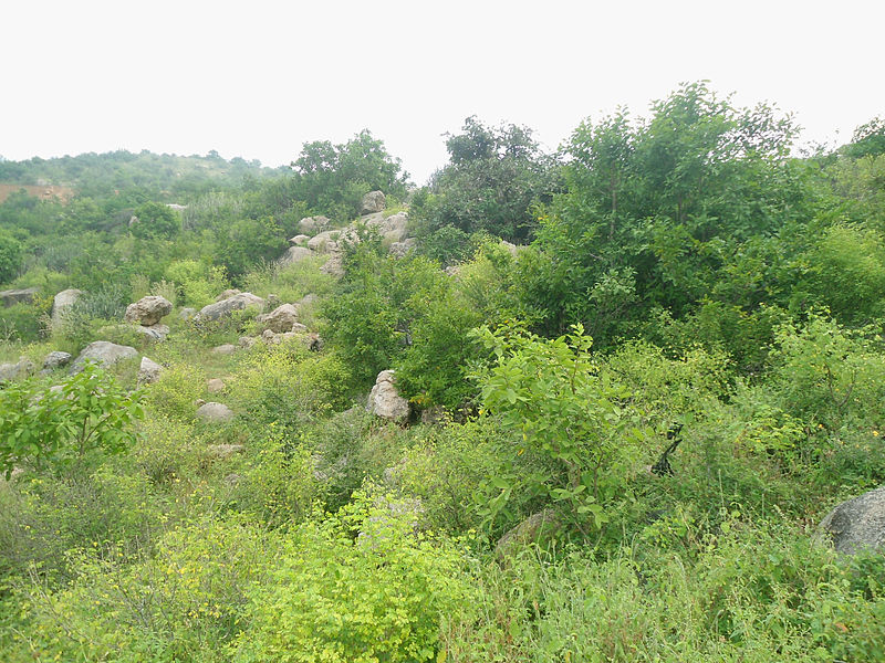
It is a type of desert forest that has scrub-like vegetation. Their trees and plants are armed with thorns and spines. These forests are found in the region where the rainfall is less than 50cm annually. The tree and plants in these regions have long roots that penetrate deep into the soil to get water from the deep.
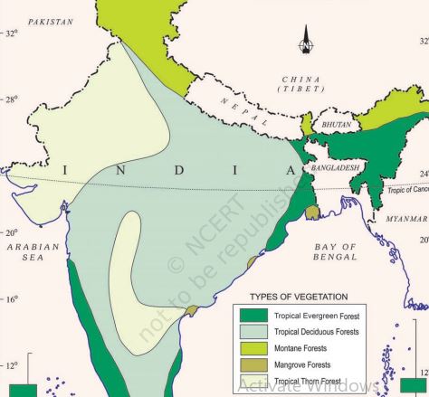
These forests are in South West Punjab, Haryana, Rajasthan, Gujarat, Madhya Pradesh, and Uttar Pradesh.
Trees found in the thorn forest in India
Examples include Babool, ber, wild date palm, Khair, neem, Khejri, palas, etc. Some of these plants are used as charcoal for cooking, and also, fodder from the forest acts as an important source of food for cattle.
Tussocky grass grows up to a height of 2m.
Tropical thorn forest in India. Source: Wikipedia by Adityamadhav83
The leaves are mostly thick and small to minimise evaporation, and the stems are succulent to conserve water.
The animals found here are rats, rabbits, wolves, tigers, lions, wild ass, horses, camels, and mice
Tropical thorn forest in India map
Tropical thorn forests in India are grouped into two based on their regions. The Northern Tropical Thorn forest and Southern Tropical Thorn Forest.
Northern Tropical Thorn Forest
These forests are found in semi-arid regions of UP, Madhya Pradesh, Haryana, Rajasthan, Gujarat, and Punjab.
These areas have rainfall of 20 to 70 cm annually. During the rainy days, rainfall will be 15 to 40 cm.
Northern Tropical Thorn Forests are grouped as Desert Thorn Forest, Ravine Thorn Forest, and Runn thorn forest.
Desert thorn examples are Prosopis spicigera, Salvadora spp, etc. Ravine thorn plant species are Acacia nilitica etc and the Runn thorn forest plant species examples are Salvadora, Tamarix, Calotropis, etc.
Southern Tropical Thorn Forest
These forests were found in the states of Madhya Pradesh, Maharashtra, Andhra Pradesh, Karnataka, and Tamil Nadu.
The average temperature here is 24 to 28 C. The annual rainfall ranges from 45 to 95 cm.
Plant species found in these forests are Acacia Nilotica, A.leucopholea, A.catechu, Prosopis spp, etc.
Peculier characteristics found in Tamil Nadu and Karnataka Tropical Thorn Forest are the formation of an umbrella-shaped crown example, Acacia planifrons.
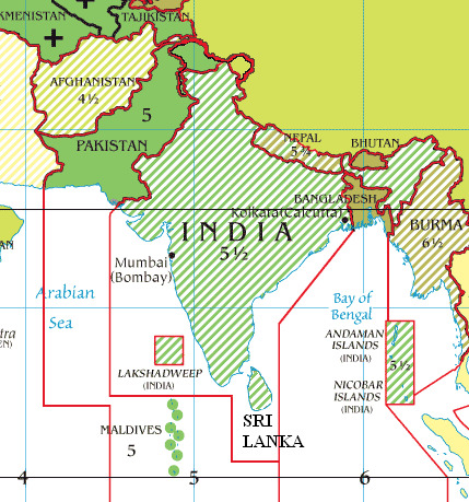
India’s standard meridian is chosen as 82°30′ E. This is called the ‘Standard Meridean’ of India‘.
India is a large country, that lies entirely in the Northern Hemisphere. India extends between latitudes 8°4’N and 37°6’N and longitudes 68°7’E and 97°25’E.
The Tropic of Cancer (23° 30’N) divides India into almost two equal parts. Indian mainland extends from Jammu and Kashmir in the north to Kanyakumari in the south.
Also Arunachal Pradesh in the east and Gujarat in the west. India has its territorial limit extending up to 12 Nautical miles (about 21.9 km) from the coast. The southern boundary extends 6°45′ N latitude in the Bay of Bengal. The latitudinal and longitudinal extent of India is roughly about 30 degrees.
Indian Standard Time By Nichalp, Ambuj.Saxena, Cpm0813 at en.wikipedia. – Source: en:Image: Timezones optimized.png Originally from en.Wikipedia; description page is/was here., Public Domain, https://commons.wikimedia.org/w/index.php?curid=1674164
Distance from North to South of India is 3214 km and East to West is only 2933 km. This difference in distance is to distance between two longitudes decreases towards the poles whereas the distance between the latitudes remains the same everywhere.
Latitudinal Extent and its Implications
The southern part of a nation lies within the tropics and the northern part lies in the sub-tropical zone or warm temperate zone. This location is responsible for the large difference in landforms, climate, soil types, and natural vegetation in the nation.
Longitudinal Extent and its Implications
There is a variation of nearly 30 degrees, which causes a time difference of nearly two hours between the easternmost and westmost parts of India. That is nearly two hours difference between Arunachal Pradesh and Gujarat.
India extent and standard meridian are chosen as 82°30′ E. This is called the ‘Standard Meridean’ of India.
Indian Standard Meridian is ahead of Greenwich Mean Time by 5 Hours and 30 Minutes. Some countries have multiple standard meridians such as the USA, which has seven time zones.
The standard meridian of India passes through Mirzapur, Uttar Pradesh. It is chosen because it is situated in the centre of all longitudes and latitudes in the country.
FAQ
What is the latitudinal extent of India?
Latitudes 8°4’N and 37°6’N and longitudes 68°7’E and 97°25’E. India lies entirely in the Northern Hemisphere.
2. The standard meridian of India passes through?
The standard meridian of India passes through Mirzapur, Uttar Pradesh.
3. Approximately what is the latitudinal and longitudinal extent of the mainland of India?
Latitudinal extent: 8°4’N to 37°6’N.Longitudinal extent: 68°7’E to 97°25’E. Mainland India has a landmass area of 3.28 Million sq. km.
4. Which latitude divides India into two halves?
23° 30’N latitude divides India into two equal halves.
Earthquake Waves are or seismic waves are the vibrations generated by an earthquake or similar energetic sources such as explosions. These are propagated within the Earth or along its surface.
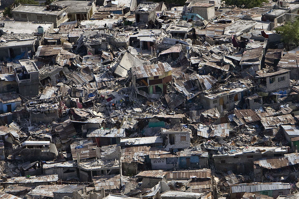
Earth quake in Haiti By UN Photo/Logan Abassi United Nations Development Programme – originally posted to Flickr as Haiti Earthquake, CC BY 2.0, https://commons.wikimedia.org/w/index.php?curid=8985699
All the earthquakes take place in the Lithosphere. A seismograph device records the waves that reach the surface.
Earthquake waves are of two types they are body waves and surface waves. The body waves are the one which is generated by the release of energy at the focus and move in all direction by traveling through the body of the earth.
These body waves interact with the surface rocks and generate a new set of waves called surface waves.
The speed of the waves varies as it passes via different densities of materials. The speed of waves is faster in the case of denser material.
The wave’s direction changes when the waves get reflected or refracted when tries to pass through the material with varying densities.
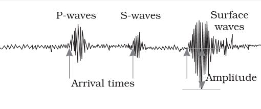
body and surface waves Earthquake waves – P-waves and S-waves Upsc
There are two types of body waves: P and S-Waves.
P-Waves
P- Waves move faster as it the one which first arrives at the surface. This wave is similar to sound waves as they travel through gas, liquid, and solid materials.
S-Waves
S-Waves arrive at the surface after P-waves. This wave travels only through solid materials. This characteristic of S-waves that it travels only through solid materials is an important thing as it helped the scientist to understand the interior of the earth.
The reflection causes the waves to rebound and refraction makes the waves scatter in all directions.
This variation in the direction of waves is studied with help of a seismograph. The surface waves are last to get recorded in the Seismograph. The Surface waves are the most dangerous as displace rocks, collapse the building structure, etc.
Magnitude and intensity of earthquake
The earthquake is scaled according to its magnitude and intensity. The Richter scale is the magnitude scale. It relates to the energy released during the quake, it is expressed in absolute numbers, 0-10.
Another Scale is the Intensity scale, where the intensity scale takes the visible damage into account. Its scale ranges from 1-12. It is named after an Italian seismologist, Mercalli.
Propagation of Earthquake Wave’s
Different types of earthquake waves travel in different manners. As they move or propagate, they cause vibration in the body of the rocks through which they pass. P-waves vibrate parallel to the direction of the wave and it exerts pressure on the material in the direction of the propagation.
As a result, it creates density differences in the material leading to stretching and squeezing of the material. The other three waves vibrate perpendicular to the direction of propagation. The direction of vibrations of S-waves is perpendicular to the wave direction in the vertical plane.
Hence, they create troughs and crests in the material through which they pass. Surface waves are considered to be the most damaging waves. The emergence of Shadow Zone Earthquake waves gets recorded in seismographs located at far-off locations.
However, there exist some specific areas where the waves are not reported. Such a zone is called the ‘shadow zone’. The study of different events reveals that for each earthquake, there exists an altogether different shadow zone.
It was observed that seismographs located at any distance within 105° from the epicenter, recorded the arrival of both P and s-waves. However, the seismographs located beyond 145° from the epicenter, record the arrival of P-waves, but not that of S-waves.
Thus, a zone between 105° and 145° from the epicenter was identified as the shadow zone for both types of waves. The entire zone beyond 105° does not receive S-waves.
The shadow zone of the S-wave is much larger than that of the P-waves. The shadow zone of P-waves appears as a band around the earth between 105° and 145° away from the epicenter.
The shadow zone of S-waves is not only larger in extent but is also a little over 40 percent of the earth’s surface.
Earthquake
It is simply the shaking of the earth. The cause of the earthquake is the release of energy, which generates waves that travel in all directions.
Causes of earthquake
The release of energy occurs along a fault. The fault is a sharp break in the crustal rocks. The rocks along the fault tend to move in opposite directions.
The overlying rock presses, the friction locks the rock together but the tendency to move overcomes the friction. Then the blocks get deformed and eventually they slide on one another abruptly and release energy, these energy waves travel in all directions.
The point where the energy is released is called the focus of the earthquake and is also called a hypocentre.
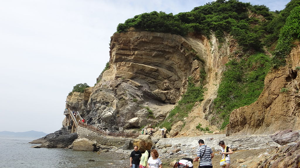
Erosion is the acquisition and transportation of rock debris. When the massive rocks break into smaller fragments due to weathering and other processes, the geomorphic agents like water, glaciers, wind, waves etc remove and transport these rock debris to other places.
By Techyan – Own work, CC BY-SA 3.0, https://commons.wikimedia.org/w/index.php?curid=27916453
Types of erosion
Water Erosion – It is the removal of soil by water and transporting away, it is due to rain, gully, rill, and stream.
Sheet and Rill Erosion – It occurs when a thin layer of soil is taken away by water when the water doe not infiltrates into the ground. Rill erosion occurs when runoff water forms small channels as it concentrates down a slope.
Scalding Erosion–Scalding occurs when water or wind removes the topsoil layer. This exposes the sodic or saline soils in the subsoil layers.
Gully Erosion-It is the process by which gullies are formed. Hillsides are more prone to gully erosion when they are cleared of vegetation, through deforestation etc.
Stream Bank Erosion – It is wearing away of the banks of a stream or river. This is distinguished from erosion of the bed of the watercourse, which is referred to as scour.
Wind Erosion -The wind is the cause of the removal of top layer soil. This occurs in arid and semi-arid lands.
These are the different types of erosion that are also responsible for Deposition.
Deposition
The deposition is the consequence of erosion. The erosional agents lose their velocity and thereby energy on the gentler slopes and the materials are carried by them start to settle.
The coarser materials get deposited first and finer materials deposit later. The deposition depression gets filled up and erosional agents act as aggradational or depositional agents also.
Karaiyar dam also called Papanasam Dam which is located 49 Km from Tirunelveli, Tamil Nadu. It is situated in the South of Western Ghat of India.
Karaiyar dam is one of the seven major dams in the Kalalkad-Mandantharai reserve area. This area is one of the 18 biodiversity hotspots in the world.
Karaiyar dam crocodiles are important fauna found here. The traveler needs to be careful while spending their time here. Slight carelessness can be fatal due to the presence of Crocodiles.
Karaiyar Dam
Karaiyar Dam was built for irrigation and other water requirement and also for power generation. Also known as Papanasam Dam and it is built over the Thabirabarani River.
This Dam height is 44 meters and its length is 227 meters. It is a picnic spot and has Kalakkad Mundanthurai Reserve. Also has boating facilities.
* * All the Notes in this blog, are referred from Tamil Nadu State Board Books and Samacheer Kalvi Books. Kindly check with the original Tamil Nadu state board books and Ncert Books.