Earthquake, its types, effect and Ways to measure it Upsc notes

An earthquake in simple words is the shaking of the earth. It is a natural event and it is caused due to release of energy that generates seismic waves that travel in all directions.

Why does the earth shake?

The shakes are due to the release of energy, that occurs along the fault. The fault is a sharp break in the crustal rocks. These rocks along the fault tend to move in opposite directions. The overlying rocks strata press them and the friction locks them together.

But over time, the tendency to move part over this friction. As a result, these blocks get deformed and slide past each other abruptly. Due to this movement, there is a release of energy and energy waves that travel in all directions.

Hypocentre

The point where the energy is released is called the focus of an earthquake or hypocentre.

Epicenter

The energy waves travel in different directions and reach the surface and the point on the surface, nearest to the focus, is called the epicenter. It is the first one to experience the waves and it is a point directly above the focus.

Types of Earthquakes

  • Tectonic Earthquakes
  • Collapse Earthquakes
  • Explosion Earthquakes
  • Reservoir Induced Earthquakes

The most common ones are the tectonic earthquakes which are generated due to the sliding of rocks along a fault plane.

A special class of tectonic earthquakes such as volcanic earthquakes, only volcanic zones.

In the areas of intense mining activity, sometimes the roofs of underground mines collapse causing minor tremors called collapse earthquakes.

Ground shaking may also occur due to the explosion of chemical or nuclear devices called explosion earthquakes.

The earthquakes that occur in the areas of large reservoirs are called reservoir-induced earthquakes.

Measuring Earthquakes

The earthquake events are scaled either according to the magnitude or intensity of the shock. The magnitude scale is known as the Richter scale.

The magnitude relates to the energy released during the quake. The magnitude is expressed in numbers, 0-10.

The intensity scale is named after Mercalli, an Italian seismologist.

The intensity scale takes into account the visible damage caused by the event. The range of intensity scale is from 1-12.

EFFECTS OF EARTHQUAKE

Ground Shaking, Differential ground settlement, Land and mudslides, Soil liquefaction, Ground lurching, Avalanches, Ground displacement, Floods from dam and levee failures, Fires, Structural collapse, Falling objects, Tsunami, etc.

The first six listed above have some bearings upon landforms.

The effect of the tsunami would occur only if the epicenter of the tremor is below oceanic waters and the magnitude is sufficiently high.

Tsunamis are waves generated by tremors and not an earthquake in themselves.

Though the actual quake activity lasts for a few seconds, its effects are devastating provided the magnitude of the quake is more than 5 on the Richter scale.

The earthquake is a natural hazard. If a tremor of high magnitude takes place, it can cause heavy damage to the life and property of people.

However, not all parts of the globe necessarily experience major shocks

Note that the quakes of high magnitude, i.e. 8+ are quite rare; they occur once in 1-2 years whereas those of ‘tiny’ types occur almost every minute.
Rock cycle and Types of rocks Upsc

Rock cycle and Types of rocks

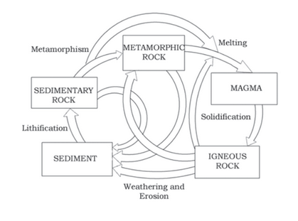
The rock cycle is a continuous process by which the old rocks are transformed into a new one. The changes are caused by various chemical and physical processes. There are three major types of rocks and they are igneous rocks, sedimentary rocks, and metamorphic rocks.

Rocks

The earth’s crust is made up of rocks and rocks are a mixture of one or more minerals. Rocks can be hard for example granite is hard and soft for example soapstone is soft.

Rocks are found in different colors. For example, Gabbro is black, quartzite is milky white. Also, rocks do not have a definite composition of minerals constituents.

The most common minerals found in the rocks are Feldspar and quartz.

The rocks are directly related to the landforms. This is studied in Petrology, which is studying the science of rocks.

On the basis of their formation, there are different rock types are classified and basically, there are three families of rocks.

  1. Igneous Rocks
  2. Sedimentary Rocks
  3. Metamorphic Rocks

Igneous Rocks

It is formed out of magma and lava. Igneous rocks are called Primary rocks. In Latin language, Ignis means Fire. These rocks are formed when magma cools and solidifies.

This cooling process and solidification process happen in the earth’s crust or earth’s surface. Based on texture, the Igneous rocks are classified. Texture means the size and arrangement of grains and also the physical condition of rock.

If the magma is cooled slowly in the greater depths, the grain size will be large. Rapid cooling of Magma on the surface produces small and smooth grains. Intermediate cooling results in the intermediate size of grains.

Example of Igneous rock is Tuff, volcanic breccia, basalt, pegmatite, gabbro, Granite.

Sedimentary Rocks

It is derived from the Latin word Sedimentum which means settling. The rocks of various types are broken up into fragments of various sizes due to various denudation agents.

Such fragments are transported to exogenous agencies and deposited and these deposits turn rocks by compaction. This process is called Lithification.

The number of layers of varying thickness in sedimentary rocks like sandstone, shale, etc. Sedimentary are classified into three types are Mechanically formed, Organically formed, Chemically formed.

Mechanically formed sedimentary rocks are Sandstone, conglomerate, limestone, shale, loess, etc. Organically formed sedimentary rocks are geyserite, chalk, limestone, coal, etc

Chemically formed sedimentary rocks are chert, limestone, halite, potash, etc.

Metamorphic rocks

Metamorphic means ‘change of form‘. The metamorphic are rocks are formed under the joint action of Pressure, Temperature, and Volume (PVT) changes.

When the rocks are subject to great pressure by the tectonic process or magma in molten states comes in contact with crustal rocks, the underlying rocks applied with great pressure by the overlying rocks, Metamorphism occurs.

Metamorphism is a manner by which previously consolidated rocks are reduced to re-crystallization and rearrangement within original rocks.

A type of metamorphism is Dynamic Metamorphism, which means without any remarkable chemical changes there occurs a mechanical disruption and change of the original minerals within rocks due to breaking and crushing.

Another type of metamorphism is thermal metamorphism and it is classified into two types and they are Contact Metamorphism and Regional Metamorphism.

The rocks come into the contact with hot intruding molten lava or magma and recrystallize under high temperature is called Contact Metamorphism.

The rock materials recrystallize due to the deformation created by tectonics shearing with high temperature or pressure or both. This is Regional metamorphism.

Foliation or lineation is the term used to mention the arrangement of minerals or grains in metamorphic rocks.

Sometimes minerals or materials of various groups are ordered into alternating slim to dense layers looking in light and dark colors, such a formation in metamorphic rocks is called Banding, and rocks exhibiting banding is called Banded rocks.

Metamorphic rocks are divided into two groups, foliated rocks, and non-foliated rocks.

Examples of metamorphic rocks are Gneissoid, granite, syenite, slate, schist, marble, quartzite, etc.

Rocks Cycle

geography optional - Physical geography of rock cycle
Rock Cycle: Physical Geography

Rocks do not remain the same, they transform this called Rock Cycle. Igneous rocks are the primary rocks, metamorphic and sedimentary rocks are other forms of these primary rocks.

The igneous and metamorphic rocks are can be fragmented and turn into sedimentary rocks. Sedimentary rocks also fragment further to become new sedimentary rocks.

The crustal rocks such as Metamorphic and Igneous rocks can sub-duct due to various movement, moves slowly to the mantle and due to high temperature it gets molten down to lava and the rocks cycle continues.

FAQ

Why igneous rocks are called primary rocks?

  • It is called primary rock because these rocks are formed from the material that comes from below the earth.

  • That is these rocks are formed from the solidification of Magma.

  • Also Igneous rock which directly or indirectly provide materials for the formation of the other types of rocks.

  • Therefor Igneous rocks are also called Mother rocks or Primary rocks.

References

Minerals and rocks Upsc

Minerals and rocks

The earth is made of different kinds of elements and these elements are in solid form in the outer layer and hot and molten form in the interior of the earth.

Around 98% of the total crust of the earth is composed of eight elements:

  1. Oxygen – 46.6%,
  2. Silicon- 27.72%,
  3. Aluminium – 8.13
  4. Iron – 5%
  5. Calcium – 3.63%
  6. Sodium – 2.83%
  7. Potassium – 2.59%
  8. Magnesium – 2.09%

Others – 1.41% (Titanium, Hydrogen, Phosphorous, manganese, sulphur, carbon, nickel, etc). There are at least 2000 minerals are identified in the earth’s crust.

But only six major mineral groups are known as Major rock-forming minerals. The rocks are made up of different minerals.

What is Mineral?

The mineral is a naturally occurring substance that is both organic and inorganic in nature.

These substances have an orderly atomic structure and definite chemical and physical properties. Minerals are composed of two or more elements and are also found single such as sulphur, gold, graphite, silver, copper, etc.

Basic Source of Minerals

The basic source of all minerals is the hot magma found in the interior of the earth.

The rocks are formed after the magma cools and then crystals of minerals appear and a systematic series of minerals appear and a systematic series of the mineral are formed.

Fossil fuels such as coal, petroleum, and natural gas are minerals that are organ substances found in Solid, Liquid, and gaseous forms respectively.

Metallic Minerals

Precious Metals – Gold, silver, Platinum, etc

Ferrous Metals – Iron, and other metals mixed with iron to form different kinds of steel.

Non-Ferrous Metals – Metals such as copper, zinc, lead, etc are called Non-Ferrous metals.

Non-Metallic Minerals

The minerals which do not contain metal are called Non-Metallic Minerals.

Example: Sulphur, Phosphates, nitrates, etc.

Cement is made up Non-Metallic Minerals.

Characteristics of Major Minerals

Feldspar

Silicon and oxygen are common elements in all types of feldspar and sodium. Potassium, calcium, aluminium, etc are found in specific feldspar varieties.

Almost half of the earth’s crust is composed of feldspar. Feldspar has a light cream to salmon pink color and it is used in ceramics and glassmaking.

Quartz

Quartz is one of the most important components of sand and granite. It consists of silica and it is a hard mineral virtually insoluble in water.

Quartz is white or colorless and it is used in Radar and radio, and also it is one of the most important components of granite.

Pyroxene

Pyroxene consists of calcium, aluminium, magnesium, iron, and silica. Pyroxene forms 10% of the earth’s crust and is commonly found in meteorites. Its color is green or black.

Amphibole

Aluminium, calcium, silica, iron, magnesium are the main elements of amphiboles. Amphibole forms 7% of the earth’s crust and it is green or black in color and used in the Asbestos industry.

Hornblende is another form of amphiboles.

Mica

Mica comprises potassium, aluminium, magnesium, iron, silica, etc. Mica forms 4% of the earth’s crust and it is commonly found in igneous and metamorphic rocks.

It is used in electrical instruments.

Olivine

Magnesium, iron, and silicon are major elements of olivine. Olivine is used in jewelry and it is usually a greenish crystal, which is often found in basaltic rocks.

Other important minerals are Chlorite, calcite, magnetite, haematite, bauxite, barite, etc.

References

Sources of information about the interior of the earth Upsc

The Earth’s radius is 6370 km. It is practically impossible to reach the centre of the Earth and conduct research on it. Due to this scientists and engineers are collecting information on the Interior of the Earth based on estimates and inferences from various sources arising from the Earth.

These estimations are classified as Direct Sources and Indirect Sources.

Direct Sources

1. Deep-Sea Drilling

The easily available solid earth materials are surface rocks. There are several deep mining has deep. Deep drilling projects such as the “Deep Ocean Drilling Project” and Integrated Ocean Drilling Project” have to give tons of information about the Interior of the earth.

Deep sea drilling projects have collected rock samples from the ocean floor, which can provide valuable insights into the Earth’s crust and upper mantle. These samples can reveal information about the planet’s geological history, the processes shaping its interior, and the composition of the underlying rocks.

For example, scientists have discovered ancient oceanic crust that provides evidence of plate tectonics and the formation of mountain ranges.

Additionally, drilling programs have uncovered valuable mineral resources, such as oil and gas.

By studying these rock samples, scientist can piece together the puzzle of the Earth’s formation and evolution.

Volcanic eruptions also provided, great information about the interiors. Magma is used for lab analysis. But it is hard to ascertain the depth of the source of such magma.

Deepest Drilled Work

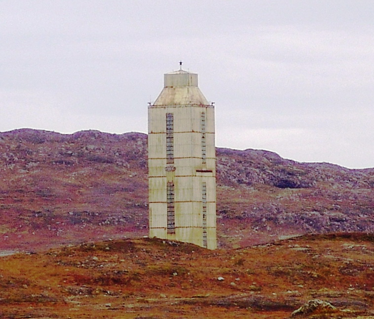
The deepest drill is at Kola, in the Arctic Ocean and the depth is about 12 km.

Indirect Sources

There are also some indirect sources from which we can get information about the interior of the earth. The temperature and pressure increase with increasing distance from the surface towards the interior in deeper depths.

Also, the density of the material also increases with depth. As the thickness of the earth is already known, a scientist has roughly estimated the value of temperature, pressure, and density of materials at varying depths.

By using Meteors, which come from outside the earth used to estimate the interior of the earth. Even though these materials come out of the earth, it is important to note that these things are made up of things that are similar to the ones we find on the earth.

The other indirect sources are Gravitation, Magnetic field, and seismic activities.

Gravitation – Gravitation force (g), which is not equal everywhere. It is greater near the poles and less at the equator.

This is because the equator is from a greater distance away from the center of the earth than the poles.

Also, the gravity values change with the mass of material, the uneven distribution of mass of materials inside the earth influences this value.

Gravity force(g), value change from place to place. This is called Gravity Anomaly. Gravity Anomaly provides us with the value of the distribution of mass of the material in the crust of the earth.

Also, magnetic surveys give us the data about the distribution of magnetic materials in the crustal portion and thereby give information about the distribution of materials in this region.

Also, seismic activities are also important sources to get information regarding the interiors of the earth.

Here’s a table detailing the sources of information about the Earth’s interior, for UPSC preparation:

CategorySourcesDetails
Direct SourcesRocks from Mining and DrillingRock samples obtained from mines and boreholes provide insight into shallow layers.
Volcanic EruptionsLava and gases from volcanic eruptions offer data on mantle composition.
Indirect SourcesSeismic WavesAnalysis of P and S waves helps understand Earth’s internal layering and properties.
Gravitational StudiesVariations in gravity reveal density differences in Earth’s interior.
Magnetic StudiesEarth’s magnetic field indicates the nature of the outer core.
Heat Flow StudiesMeasurements of geothermal gradient give clues about temperature distribution.
MeteoritesComposition of meteorites is comparable to Earth’s core and mantle materials.
Geophysical MethodsRadiometric DatingProvides information on the age of rocks and Earth’s formation history.
Electrical ConductivityConductivity variations suggest the presence of materials like molten rocks.
Density StudiesData from the behavior of seismic waves help estimate density variations.
Astronomical InsightsEarth’s Orbital MovementsIndicate mass and density distribution of the planet.

Indian Standard Time (IST): Longitude, States & Map [Upsc Exam Special]

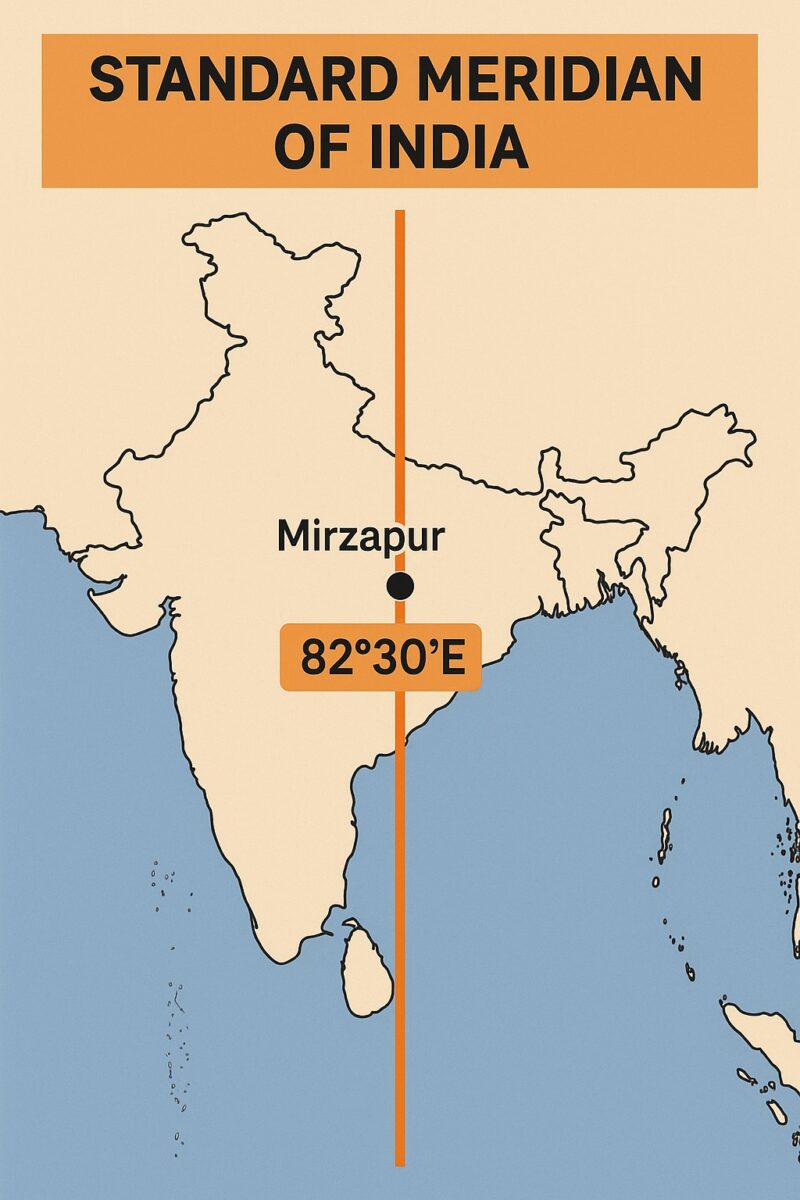
Indian Standard Time, also known as IST, is the official time observed throughout India. It is calculated based on the standard meridian of India, which is 82°30’E longitude. This Indian Standard Time Meridian passes near Mirzapur in Uttar Pradesh.

As per international timekeeping, IST of India is +5:30 hours ahead of Greenwich Mean Time (GMT) or the Greenwich Meridian. This makes the Indian Standard Meridian unique compared to other countries that follow full-hour time zones.

The clock tower in Mirzapur near Allahabad, Uttar Pradesh, is approximately on the corresponding longitude reference line, and Indian Standard Time is calculated on the basis of 82.3 degrees east longitude. Thus, Indian standard time (IST) refers to the local time of Mirzapur near Allahabad.

In India, the sun rises nearly two hours earlier in the northeast (Arunachal Pradesh) than in the west (Gujarat). This means that people in the east start their day in the dark, and their work hours extend well past sunset. This can disrupt sleep patterns and overall health.

standard meridian of india on map
Indian standard time line in the India Map

Longitude and Time

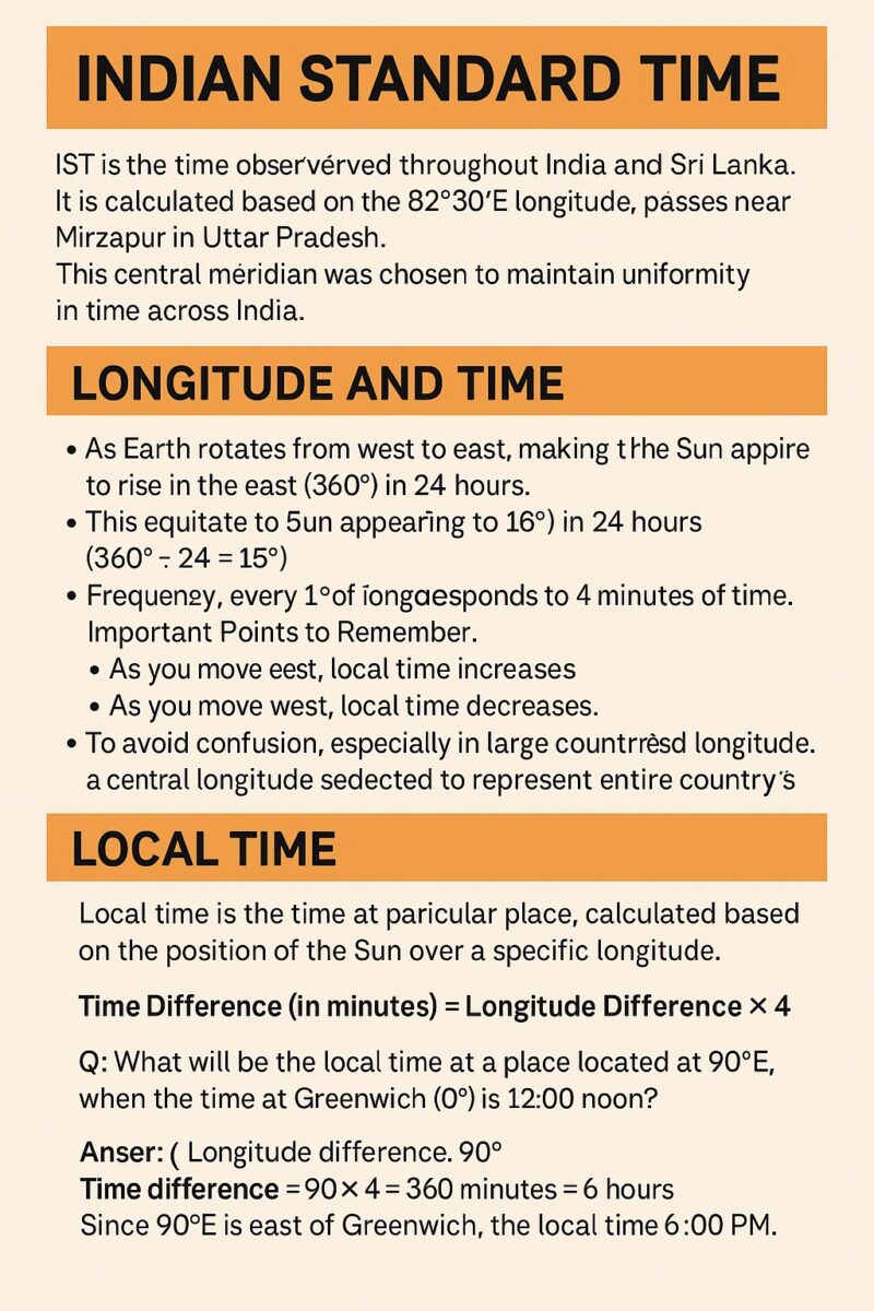
Time zones across the globe are derived from the longitude system of the Earth. The Earth is divided into 360° of longitude, and it rotates from west to east, completing one full rotation in 24 hours. This rotation creates the effect of sunrise in the east and sunset in the west.

  • There are 180° of longitude both east and west of the Prime Meridian (0°).
  • The sun moves across 15° of longitude per hour, meaning 1° of longitude = 4 minutes.
  • Thus, as we move eastward, the time increases, and as we move westward, it decreases.
Indian standard time line in india and line passes through which states Upsc
Indian standard time line mindmap

Local Time

Local Time refers to the time observed at a particular location, depending on its longitude. It is calculated with respect to the Greenwich Meridian (0°) and the longitude of the location.

The misalignment of official time with natural daylight leads to wasted daylight hours in the morning and an increased reliance on artificial lighting in the evening. Studies in India have shown that adopting two time zones could lead to significant energy savings. Some regions, like the tea gardens of Assam, have even adopted an unofficial “Chaibagaan time” that is one hour ahead of IST to better utilise daylight.

Example for UPSC Aspirants:

If a place lies at 90° East, what would be the local time when it’s 12:00 noon at Greenwich?

  • Difference in Longitude = 90°
  • Time Difference = 90 × 4 = 360 minutes = 6 hours
  • Local Time = 12:00 noon + 6 hours = 6:00 PM

As the place is east of Greenwich, it adds to GMT. If it were west, we would subtract.

Indian Standard Meridian

To ensure a uniform standard time across the country, countries adopt a Standard Meridian. This is usually a longitude that is a multiple of 7°30’ or 15°, making it easy to express time differences with GMT in whole or half hours. The discrepancy between official time and the sun’s position can lead to a loss of productivity, as people’s natural biological clocks are not in sync with their work schedules.

India’s Standard Meridian:

  • The Standard Meridian of India is 82°30’E.
  • It is called the Indian Standard Meridian, and IST is based on this longitude.
  • This Indian Standard Longitude passes near Mirzapur, not exactly through the centre, but close enough to serve national standard time purposes.

This meridian is commonly referred to in exams like UPSC as Indian Standard Time Meridian or India Standard Time Meridian.

FeatureGreenwich Mean Time (GMT/UTC)Indian Standard Time (IST)
Reference Longitude0° (Prime Meridian)82° 30′ E (Standard Meridian)
Time Offset+0:00 Hours+5:30 Hours
Location BasisRoyal Observatory, LondonMirzapur, Uttar Pradesh
CalculationBase Reference82.5° × 4 minutes per degree
Current StatusGlobal StandardIndia’s Single Time Zone
Comparison table between IST and GMT

Time Zones and India’s Extent

Although India’s geographical extent spans nearly 30 degrees in longitude (from ~68°E to ~97°E), it follows only one time zone – IST.

  • Unlike Russia (11 time zones), the USA (6), and Canada (6), India and China maintain a single time zone to avoid administrative complications.

The Indian standard time line in India, and the line passes through which states

Indian standard time line in India is crucial because it serves as the reference meridian for calculating the single time zone used across all of India. The local time at this meridian is considered the standard for the entire country.

The Indian Standard Time line passes through five states:

  1. Uttar Pradesh: The IST meridian is famously recognised for passing through the city of Mirzapur (and nearby Allahabad/Prayagraj), which is often cited as the reference point for calculating.
  2. Madhya Pradesh: The line crosses the state, influencing its timekeeping.
  3. Chhattisgarh: The meridian passes through the eastern part of the state.
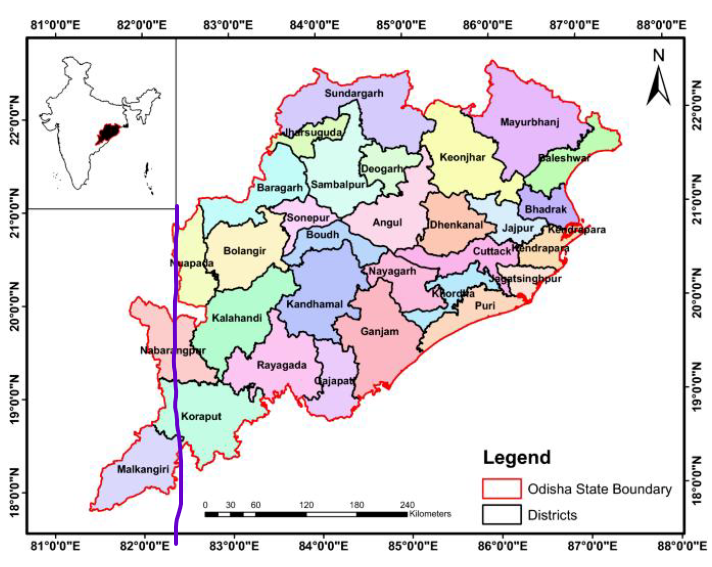
  4. Odisha: The IST line runs through a significant portion of Odisha. The Districts through which it moves in Odisha are: Nuapada, Nabarangpur, Koraput, and Malkangiri.
The Districts over which it moves in Odisha are: Nuapada, Nabarangapur, Koraput and Malkangiri.
IST passes through Nuapada, Nabarangapur, Koraput and Malkangiri districts of Odisha

5.Andhra Pradesh: The meridian passes through the southeastern part of Andhra Pradesh.

    Using a single standard time zone helps to ensure uniformity and avoid confusion in daily activities, such as railway and flight schedules, despite the country’s vast longitudinal extent.

    In the USA and Canada, the time zones often align with states and provinces, which have a high degree of autonomy. This makes it easier for different regions to manage their own economies and social schedules. For example, the business day on the West Coast can overlap with part of the business day on the East Coast, facilitating commerce.

    Conclusion

    To summarize:

    • Indian Standard Time is calculated from the 82°30’E meridian.
    • It is +5:30 hours ahead of GMT.
    • The IST meridian passes through India, near Mirzapur, and is vital for national synchronisation.
    • This single-zone approach, despite India’s vast extent, is a unique administrative decision.
    • Understanding the Indian meridian, IST, and the Greenwich Meridian in India is crucial for geography, general awareness, and UPSC preparation.

    Also, check the International Date Line

    References

    NCERT Geography Notes for UPSC

    Physical Geography

    Rotation and revolution of earth Upsc

    Rotation and revolution of earth

    Earth has two types of Motions. They are Rotation and Revolution. Rotation is the movement of the earth on its axis. Earth takes 24 hours for one rotation around its axis. This period of rotation is known as Earthday.

    Revolution is the movement of the earth around the sun in a fixed path or orbit. Earth motion around the sun in its orbit, which the earth takes 365 days which is measured as 1 year. Also, 6 Hours is ignored for convenience.

    These 6 Hours are saved every year to make one day (24 Hours) and this extra day is added to the month of February. Thereby every 4th year there will be 29 days instead of 28 days. The year with 366 days is called a leap year.

    The Axis of the Earth is an imaginary line, which makes an angle of 66° with its orbital plane. An Orbital Plane is a plane formed by orbit.

    Effects of Motion of Earth

    The earth receives sunlight from the sun. Only half side of the earth receives sunlight at one point and the other of the earth does not receive sunlight.

    The side that receives sunlight is the Day, the side which does not receive Sunlight is the night. This is because of the Spherical shape of the earth.

    The circle of Illumination is the circle which divides the day from night on the Sphere of Earth (Globe). This circle does not coincide with the axis.

    Seasons of Earth

    The season in the Earth is caused by the inclination of the earth in the same direction and revolution around the sun in an elliptical orbit. Every year is divided into Summer, winter, spring, and autumn seasons.

    The change of season is because of the earth’s position around the Sun.

    Summer Solstice

    The Northern Hemisphere is tilted towards the sun on 21st June. The Sunrays fall directly on the Tropic of Cancer, the areas near the Tropic of Cancer receive more heat.

    The regions near the Poles receive less heat are the Sun rays fall of Poles are Slanting. The North Pole which is inclined towards the Sun and the areas beyond the Arctic circle experiences continuous daylight for six months.

    The Summer occurs North of the equator, as the large portion of the Northern Hemisphere is getting Sunlight. At these places, on June 21, the longest day and the shortest night occurs.

    In the Southern Hemisphere, this condition is opposite, where the Southern Hemisphere has winter, where the Nights are longer than the days. The above-mentioned points are all the characteristics of Summer Solstice.

    Winter Solstice

    On 22nd December, the Tropic of Capricorn receives direct rays of the Sun. This is because the South Pole is tilted towards the Sun.

    As the result, the rays of the Suns fall vertically at the Tropic of Capricorn which is 23° S and by this Southern Hemisphere receives more sunlight. Therefore, it is Summer in Southern Hemisphere and Winter in Northern Hemisphere.

    The Days in the Southern Hemisphere is longer than the Nights. This position of the earth is called Winter Solstice. Australia is a good example for Winter Solstice, and it has Summer during December and celebrates the Christmas festival in the Summer Season.

    Equinox

    During Equinox, the direct Sun Rays fall on the equator. At this position, neither the North Pole and the south pole is tilted towards the Sun. As a result, the whole earth experiences equal days and equal nights.

    This position of the earth is called the Equinox. It happens on 21st March and September 23.

    On September 23, it is Spring season in the Southern Hemisphere and Autumn in the Northern Hemisphere. On March 21, it is Spring season in the Northern Hemisphere and Autumn in the Southern Hemisphere.

    References

    What safety measures should be taken during lightning and thunderstorm?

    This post is for the topic of thunderstorms and lightning Upsc.

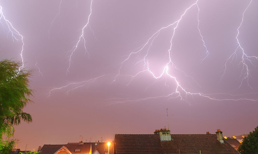
    Lightning is an atmospheric electrostatic discharge (spark) accompanied by thunder, which typically occurs during thunderstorms, and sometimes during volcanic eruptions or dust storms.

    Lightning generates 10-20 ampere current dangers for people in an open area. Lightning strikes often have fatal consequences.

    On average, 2000 people die from lightning in the world every year.

    Lightning mostly strikes tall things, such as trees that break down and catch fire or it may strike power transmission lines and antennas fastened on roofs and buildings which causes the fire.

    The air temperature, when lightning occurs, is as hot as 9982.2 °C. Thunder is the sound caused by lightning. A charged, super-heated lightning bolt creates a “resonating tube” as it travels.

    The air in the tube rapidly expands and contracts to cause vibrations that we hear as the rumble of thunder. Lightning strikes can explode a tree.

    Imagine 15 million volts of electricity hitting a tree branch. The heat travels through the tree, vaporizing its sap and creating steam that causes the trunk to explode.

    Before lightning

    If you are planning to go to the countryside, check the weather forecast. If a thunderstorm is expected it is better to postpone the trip.

    It is good if you can estimate the distance to the front line of a thunderstorm. In order to do this, you must check the time interval from the moment you see the lightning until you hear thunder.

    Lightning always precedes thunder. We know that the sound speed travels on average about 1km every 3 seconds.

    Reduction of the time interval between the sight of lightning and the resulting thunder means that the danger is approaching and protective measures must be taken.

    If there is no interval between lightning and thunder means, it means that the cloud is already over your head.

    During Lightning

    If you are in a building it is necessary to close windows, doors, ventilation pipes,, and chimneys. It is necessary to turn off the telephone, TV set, and other electrical equipment because lightning may strike electrical cables and pass-through wiring.

    Do not take a shower because both water and metal conduct electricity. Do not light the fireplace because the heat coming from the chimney may attract lightning.

    It is better to stay away from electric wires, lightning rods, water pipes, antennas, and windows.

    If you are in an open area during a thunderstorm, do not stand under a tall tree. Lighting is most damaging for tall trees. It is better to stay 30-40 meters away from them. Avoid trees that are standing separately. Remember that lightning does not strike bushes.

    If the area is open, it is better to find a lower place or a cavity and squat there. It is dangerous to stand or lie down on the ground because this increases the exposure area.

    It is necessary to get rid of metal items such as a bicycle, coins, etc. Do not stand under an umbrella.

    Do not run during the occurrence of lightning; move slowly towards a shelter because the airflow may attract lightning;

    If you are in a car, do not get out. It is better to close the windows and turn off the antenna. Do not park your car under tall trees or any structures that may fall down and hit you.

    If there is an injured person next to you, remember that the victim may lose consciousness. It is necessary to provide first aid. Cover your mouth with wet cloth in order to protect your lungs.

    Drought management in India Upsc

    Drought in India

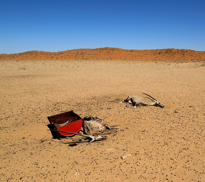
    Drought is a period of time (months or years) during which a part of the land has a shortage of rain, causing severe damage to the soil, crops, animals, and people.

    It sometimes causes even death. During drought high temperature is experienced and such conditions may affect our health. The primary cause of drought is a deficiency of rainfall and in particular, the timing, distribution, and intensity.

    In India, around 68 percent of the country is prone to drought. Of the entire area, 35 percent receives rainfalls between 750 mm and 1,125 mm which is considered drought-prone while 33 percent of areas that receive rainfalls less than 750 mm is considered to be chronically drought-prone.

    The five states that are most vulnerable to droughts are Assam, Andhra Pradesh, Maharashtra, Karnataka, and Bihar. Coincidently these states are also vulnerable to cyclones, floods.

    Drought management in India Upsc
    By Dumbassman – Own work, CC BY-SA 4.0, https://commons.wikimedia.org/w/index.php?curid=85661296

    Drought management in India

    Drought management in India involves Monitoring and Early warning system, Drought Declaration, and Providing Drought relief. The development of such a system involves coordinated efforts from State governments, Union governments, farmers, and Scientific institutions.

    The Union Ministry of Agriculture is responsible for monitoring and managing drought conditions.

    Monitoring and Early Warning System

    As all the states in India are drought-prone, setting up a drought monitoring and management system is very important. This Monitoring system provides an integrated approach to the management of drought.

    The Monitoring system will cover all aspects of drought such as early warning, forecasting, response, and mitigation.

    IMD (India Meteorological Department)

    This agency provides early warnings and forecasts for droughts. IMD forecasts droughts on the basis of:

    • Long range forecasts of seasonal total rainfall of entire country
    • rainfall summaries are compilled weekly based on precipitation at district level

    Agriculture Meteorology Division

    This is the specialized division of IMD based in Pune that has a wide network of agro-meteorological observatories that provides different types of data on agro-meteorological parameters.

    Before drought:

    • Rainwater harvesting should be followed.
    • Sewage water should be recycled and used for domestic purposes.
    • Building canals or redirecting rivers for irrigation.
    • Utilize water economically.

    During drought:

    • In case of overheating, immediately move to a shady area.
    • Consume adequate amounts of water stay.
    • Wear cotton clothing and a hat.

    After drought:

    • If anyone faints after sunstroke, emergency medical measures should be taken.
    • Contact local government agencies to receive information about disaster and assistance for the population.

    Drought prone areas in India

    Out of India’s total geographic area, almost one-sixth is drought-prone, that is 16% of the total land. This affects almost 12-15% of the total population every year. But more than 40% of India on the process of getting drought and 68% of the country is prone to drought.

    Rajasthan is the most affected and drought-prone area in India. Other most drought-prone areas in India are:

    • Tirunelveli district, Tamil Nadu.
    • Coimbatore, Tamil Nadu.
    • Saurashtra and Kutch regions in Gujarat.

    • Mirzapur plateau and Palamu regions in Uttar Pradesh.
    • Purulia district, West Bengal.
    • Kalahandi region, Orissa.

    Below is region-wise drought-prone areas:

    NORTH

    • Jammu and Kashmir – Ladakh
    • Himachal Pradesh – Lahaul and Spiti
    • Punjab – South west, Malwa
    • Haryana – South west
    • Uttarakhand – Kumaon
    • Uttar Pradesh – Bundelkhand

    WEST

    • Rajasthan – Marwar, parts of Mewar
    • Gujarat – Kachchh, north Kathiwar
    • Madhya Pradesh – Malwa,
    • Maharashtra – leeward side of Western Ghats

    SOUTH

    • Karnataka – North east
    • Tamil Nadu – central districts on leeward side of Anamalai Range
    • Andhra Pradesh – Rayalseema, south Telengana

    EAST

    • Chattisgarh – North, Bastar
    • Orissa – western interior districts eg Kalahandi 
    • Jharkhand – east Singhbhum, Palamau
    • West Bengal – Purulia 

    References

    Flood management in India UPSC

    Flood disaster management upsc

    Flood destruction has always brought misery to numerous people, especially in rural areas. Flood results in the outbreak of serious epidemics, especially malaria and cholera. Simultaneously, the scarcity of water also arises. It has a drastic effect on agricultural produce.

    Sometimes, water remains standing over large areas for a long span of time hampering the Rabi crops. India is one of the most flood-prone countries in the world. The principal reasons for flood lie in the very nature of natural ecological systems in this country, namely, the monsoon, the highly silted river systems, and the steep highly erodible mountains, particularly those of the Himalayan ranges.

    The average rainfall in India is 1,150 mm with significant variation across the country. The annual rainfall along the western coast and the Western Ghats, Khasi hills, and over most of the Brahmaputra valley amounts to more than 2,500 mm.

    Twenty-three of the states (29) and union territories (6) in the country are subject to floods and 40 million hectares of land, roughly one-eighth of the country’s geographical area, is prone to floods. The National Flood Control Program was launched in the country in 1954.

    Do’s before the flood

    • Keep furniture and electrical appliances on beds and tables
    • Put sandbags in the toilet bowl and cover all drain holes to prevent sewage backflow.
    • Keep your mobile charged
    • Listen to the radio or watch television for the latest weather bulletin and flood warnings.
    • Keep strong ropes, a lantern, battery-operated torches, extra batteries ready.
    • Keep umbrellas and bamboo sticks with you for protection from snakes.
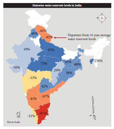
    emergency management -Statewise water reservoir levels in India
    * * All the Notes in this blog, are referred from Tamil Nadu State Board Books and Samacheer Kalvi Books. Kindly check with the original Tamil Nadu state board books and Ncert Books.